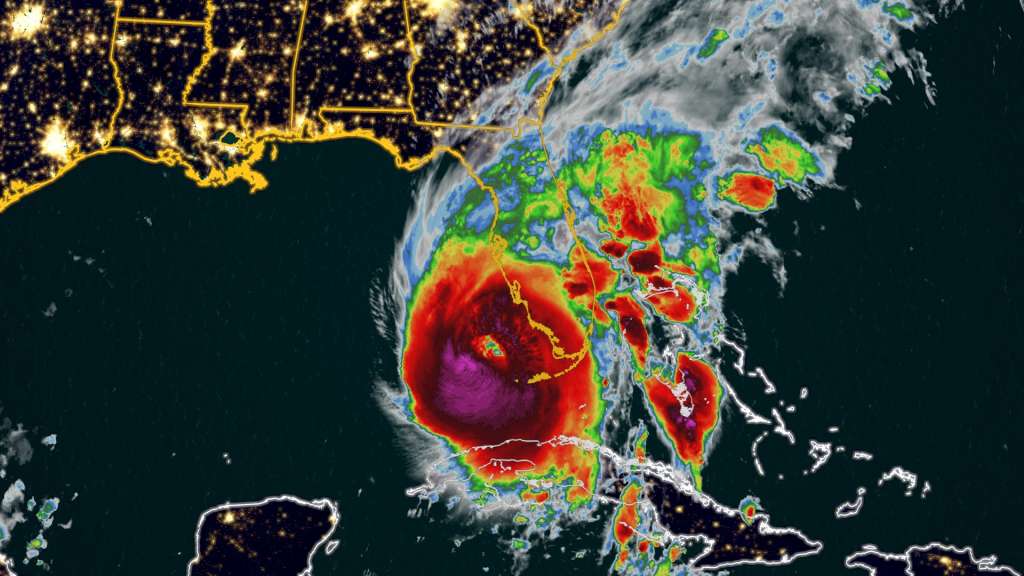
(CNN) — Hurricane Ian — now a stronger and “extremely dangerous” Category 4 storm — has begun lashing Florida with major flooding and ruinous winds as it advances on a large swath of the state’s west coast with the potential within hours to inflict catastrophic floods and life-threatening storm surge.
“Conditions rapidly deteriorating along the southwest Florida coast,” the National Hurricane Center said Wednesday morning, with Ian’s center just 55 miles from the coast. Its maximum sustained winds were 155 mph — just 2 mph short of a Category 5, the center said at 7 a.m. ET.
The area between Naples and Sarasota faces the highest threat of dangerous storm surge, the hurricane center said. More than 2.5 million people have been advised to flee, including 1.75 million under mandatory evacuation orders — no small ask in a state with a large elderly population, some of whom have to be moved from long-term care centers.
After pummeling Cuba on Tuesday and leaving an islandwide blackout, Ian is taking aim at Florida’s vulnerable Gulf Coast, where residents have been boarding up and leaving in droves on congested highways. Schools, supermarkets, theme parks, hospitals and airports have announced closures. The Navy moved its ships, and the Coast Guard has shut down ports.
Parts of far southern Florida already have begun feeling the storm’s first effects, with tropical storm-force winds and at least two possible tornadoes reported in Broward County, including at North Perry Airport, where planes and hangers were damaged. Major flooding was being reported in Key West due to storm surge, along with power outages.
“The time to evacuate is now,” Florida Division of Emergency Management Director Kevin Guthrie said Tuesday, calling Ian “a statewide event.”
As winds pick up, officials may close bridges, complicating evacuations for those who don’t leave right away. Gas stations may also temporarily run out of fuel, Gov. Ron DeSantis said.
Water levels already were hitting about 2.5 feet above Mean Higher High Water — the third highest level behind 2005’s Hurricane Wilma and 2017’s Hurricane Irma, CNN Meteorologist Robert Shackelford said.
A hurricane warning is in effect on Florida’s Gulf Coast from Chokoloskee to the Anclote River, including Tampa Bay, and in the Dry Tortugas. A storm surge warning is in effect for coastal areas, including Tampa Bay.
Life in Florida upended as residents prepare for landfall
In Tampa, police went door to door Tuesday in a mandatory evacuation zone, making sure residents are ready to flee.
Projections earlier had Hurricane Ian on track to directly hit Tampa Bay, which would have been the first direct hit in 100 years. While the hurricane’s path has shifted south, Tampa Mayor Jane Castor said mandatory evacuations and preparations are continuing.
“No matter where it lands, if it does come in a little south of us, we are not getting out of this unscathed and there is going to be flooding throughout the Tampa Bay area,” Castor said.
The governor warned there will be “catastrophic” flooding and life-threatening storm surge in the Gulf Coast region, with the highest risk in southwest Florida, from Naples to Sarasota.
Preparations across the state have been underway for days as residents braced for Ian’s wrath. People were lining up to pick sandbags or flocking to stores to stock up on supplies like water and batteries.
And as the hurricane marched closer, the closures began.
Throughout Florida, 58 school districts have announced closures due to this storm as campuses turned into shelters for those evacuating from their homes.
Disney World is set to close Wednesday and Thursday, and so is Kennedy Space Center’s Visitor Complex.
Hundreds of Publix grocery stores shut their doors Tuesday evening and were expected to remain closed through Thursday.
As millions evacuate, 176 shelters opened statewide and hotels and Airbnbs became available for people leaving evacuation zones, the governor said.
Local governments and state agencies have also been preparing those living in nursing homes and other senior care facilities to evacuate.
Florida has around 6 million residents over the age of 60, according to the state’s Department of Elder Affairs — nearly 30% of its total population. As of Tuesday, all adult day cares, senior community cafes, and transportation services in evacuation zones are closed, according to the department.
Authorities have also been readying services to fan out and respond to calls for rescue and then, in the aftermath of the hurricane, for recovery and repair efforts.
Nearly 400 ambulances, buses, and support vehicles were responding to areas where the hurricane was expected to make landfall, according to the governor’s office.
DeSantis activated 5,000 Florida National Guard members for Ian’s response operations, and 2,000 more guardsmen from Tennessee, Georgia and North Carolina are also being activated to assist.
Florida officials were also preparing to activate the state’s urban search and rescue teams.
“We have five state teams that are activated with additional five FEMA teams that are in play,” Florida Chief Financial Officer Jimmy Patronis said at a news conference Tuesday night. “We have over 600 resources to bear in addition to these out-of-town teams.”
After landfall, Ian will crawl over Florida
Strengthening Hurricane Ian is well defined, with a clear eye, National Hurricane Center acting Director Jamie Rhome said in a Tuesday evening update.
“This is not what you want to see in the eastern Gulf of Mexico,” Rhome said.
When the hurricane hits, rising water is expected to move inland from the coastline, bringing life-threatening inundation and flooding to coastal areas.
Millions of people are under a storm surge warning, including the Suwannee River southward to Flamingo, Tampa Bay and the Dry Tortugas.
The area from Longboat Key to Bonita Beach, including Charlotte Harbor, could get up to 12 feet of storm surge, according to the hurricane center.
Warnings are also in place on the state’s east coast from the Flagler-Volusia county line to the mouth of the St. Mary’s River and along the St. Johns River.
After landfall, Ian is expected to crawl across the central part of the state, with damaging winds bringing the threat of tornadoes through Wednesday, according to the National Weather Service.
The slow churn over will “dump an enormous amount of rain on the state of Florida,” DeSantis said.
Ian is expected to dump at least 2-3 months’ worth of rainfall by Friday. Central and Northeast Florida is expected to get 12 to 18 inches of rain, while the Florida Keys and South Florida could get 6 to 8 inches.
Central Florida is expected to see “widespread catastrophic flash, urban, and river flooding” while the southern part of the state should brace for “considerable flash, urban, and river flooding,” the center said.
Under current projections, the hurricane is going to work its way from Southwest Florida, up to the central part of the state, then emerge over the Atlantic Ocean by late Thursday, when it could strengthen again and affect another part of the US.
(Copyright (c) 2024 CNN. All Rights Reserved. This material may not be published, broadcast, rewritten, or redistributed.)