To say my winter outlook from last winter was a dumpster fire would be an understatement….
I thought we would have a cold and snowy winter but it was pretty much the exact opposite. I’ll spare you the excuses but basically, the atmosphere failed to behave in a way I thought it would. As I look at the atmosphere again for this winter…I wonder if my forecast was just ahead of its time?? Yup, I’m doubling down on the belief that this winter will offer above normal snow and below normal temps!
We’re on to Winter 2019-2020! Some general thoughts on the winter:
* Overall, Colder Than Normal Temperatures
* Seasonably mild in December. January is tug of war between mild and cold with February and March cold.
* As for snow….much more snow than last year (which was 27”) and I think all the winter months (Dec-March) have at least 1 impactful snowstorm.
Like last year, I always like to start with the state of the Pacific Ocean.
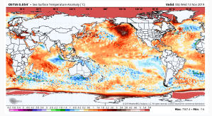
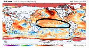
Focus on the second pic with the equatorial Pacific highlighted. That is where we look for El Nino/La Nina signals (El Nino=warmer than normal ocean water (orange) inside that encircled area and La Nina is when you would find cooler than normal (blue) ocean water inside that encircled area.
Unlike last year, it looks like this year ENSO (El Nino-Southern Oscillation) will be in the neutral state with perhaps an El Nino Modoki shadow (warmer water central equatorial Pacific and cool water eastern equatorial Pacific). Without a clear signal of either El Nino or La Nina, the natural tug-of-war between the two phases and other atmospheric phenomena take a break…
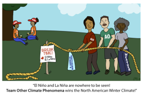
You see two of the participants with t-shirts labeled MJO and AO. Let’s start with the MJO…Madden-Julian Oscillation. I touched upon this in last years outlook. Here is an excerpt… I won’t bore you too much with detail but essentially it is a planetary wave that travels across the tropical portion of the world. The atmospheric wave can enhance precipitation and suppress precipitation (as well as temperature), depending on its phase. The MJO can also influence the position of the jet stream across North America leading to enhanced warm and cold spells, depending on the phase the MJO is in. Knowing which phase the MJO will spend winter in is difficult to at best but looking at sea surface temps (yet again) can give us clues……whew…that’s a mouth-full! When we look at the Indian Ocean we see a dipole in water temp anomalies…

(warm west /cool east). This is known as a positive Dipole (a rather strong one I might add). A positive IOD tends to suppress convection in the eastern Indian Ocean and is expected to continue that in December and perhaps January. This suppression may keep the warm phases of the MJO muted and brief at the start of winter….ergo, keeping our winter warm spells muted and brief (yes, warm spells are going to happen). I really got smoked on this last year as the MJO did spend quite a bit of time in the warm phases in December-January and a part of February. I’m once again banking on the notion of the MJO spends limited time in the warm phases this winter…we shall see!
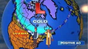
Now onto the AO….The Arctic Oscillation. In a nutshell, the AO is the atmospheric circulation pattern that flows around the northern hemisphere…or in other terms, jet-stream positioning. The AO has two phases…a positive phase and a negative phase. The positive phase features low pressure around-near the arctic circle and usually means mild weather for the United States. See below
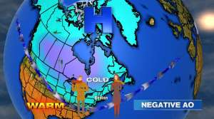
The negative phase of the AO, conversely has high pressure around/within the Arctic Circle. This phase usually means cold and stormy weather for the United States. See below
So what phase will the AO be in this winter? That is a GREAT question. In the short term, the weather models indicate (show gfx) but that only gets us as far as the next few weeks (and not very reliable).
There has been fascinating research done by a gentleman by the Name of Dr Judah Cohen. He is the Director of Seasonal Forecasting at AER (Atmospheric & Environmental Research). His research has found that when Siberian Snow Cover extent builds rapidly in October, it tends to favor a -AO and conversely, when the Siberian Snow Cover extent is slow to build in October, a +AO transpires the following winter. What was the Snow Cover extent this past October? It was above normal, so based on his work, we would tend to presume a -AO is more likely than a +AO this winter. In fact, the record cold in November can, at least partially, be attributed to that -AO!
Which leads me to my final point…..As November goes, so goes the upcoming winter. There is a moderately strong correlation to a cold November here in the northeast usually means a cold upcoming winter.
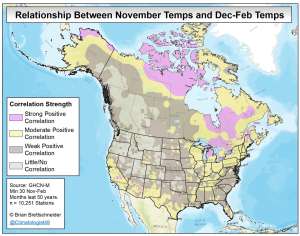
(Graphic courtesy Brian Brettschneider twitter.com/Climatologist49 )
As of this writing (through November 14), the month-to-date temps are colder than normal and it does not appear that the month will finish with an above normal average and that would tend to suggest colder than normal temps are likely to continue through the winter for New England (especially northern New England). Oddly enough, November of 2018 was colder than normal but the winter finished above normal.
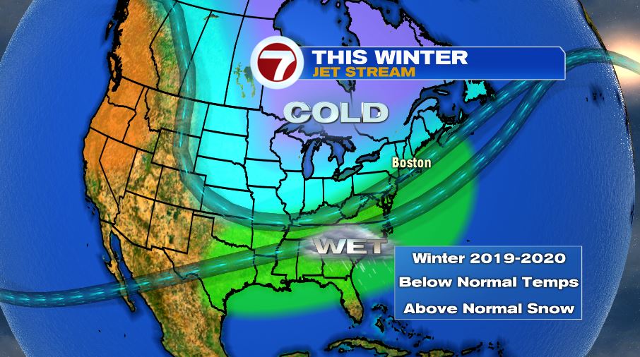
And so with that, this is what I anticipate the jet stream to look like for the upcoming winter:
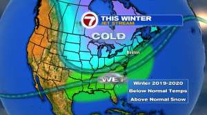
Fairly close to what I thought would happen last winter (but didn’t. Ouch. Very Ouch). Cold focused across the upper Midwest, Great Lakes and much of the interior Northeast with New England being right near the storm track (and an enhancement of moisture from a subtropical jet stream). This placement of the main jet stream would mean a winter average (December-February) of temperatures below normal with a monthly breakdown playing out with December slightly above normal and January-February below normal.
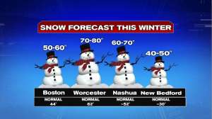
In terms of snowfall, Boston only picked up ~28” of snow (with 25” of the 28” happening in February and March!). I think with a storm track nearby and more cold on the playing field than last year, Boston snowfall—as well as much of New England–likely to finish above normal. Here are some numbers:
There you have it, the winter outlook! #EmbraceWinter
~JR