Last February, as you no doubt remember, started off with bitter cold temps and over 16" of snow on the 2nd. This February couldn’t be more different. Maybe this is Mother Nature’s way of paying us back. In reality, a typical El Nino weather pattern is partially responsible. Record high temps for Monday are in the 60s. That should be out of reach but we will at least be in the ballpark with highs in the mid to upper 50s! Some isolated showers are possible Monday afternoon but most of us stay dry.
Tuesday will be slightly cooler, but still well above average for Groundhog Day. Despite mostly sunny skies and mild temps, I will probably still spend most of the day inside watching every weatherperson’s favorite holiday movie…Groundhog Day.
Rain is likely on Wednesday. The atmosphere will be unusually unstable for early February thanks in part to the unusually warm temperatures in the mid to upper 50s. The National Weather Service calls it "amazing for early February" That instability will lead to some heavier showers and strong wind gusts Wednesday afternoon. The record highs for Wednesday are 59 in Boston set in 1991 and 56 in Worcester set in 1991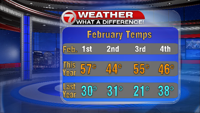 .
.