(CNN) — A tropical depression is poised to hit the same northern Bahamian islands that Hurricane Dorian ravaged earlier this month — and it may be a tropical storm when it does.
The system is expected to send heavy rain and stiff winds to the Abaco Islands by Friday night and Grand Bahama island by Saturday morning, areas where teams are still searching for hundreds of people reported missing in the aftermath of Dorian.
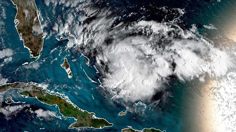
The storm strengthened into a tropical depression Friday afternoon, and likely will grow in strength into a tropical storm named Humberto, with maximum sustained winds of at least 39 mph, over the next day, forecasters say.
Regardless of wind strength, “there will be rain … over (an) area that certainly doesn’t need any rain,” CNN meteorologist Chad Myers said.
The center of Tropical Depression Nine was about 140 miles east-southeast of Great Abaco at 5 p.m. ET Friday, with maximum sustained winds of 30 mph, the National Hurricane Center said.
Looking further ahead, the storm could move north just off the Florida’s Atlantic coast with tropical-storm-force winds Saturday afternoon into early Sunday, forecasters say.
Tropical storm warnings have been issued for areas of the northern Bahamas. A tropical storm watch has been issued for portions of the east coast of Florida, affecting about 3 million people, according to forecasters.
Heavy rain expected over Dorian-impacted islands
From Friday evening through Sunday morning, this system could generally bring 2 to 4 inches of rain to Great Abaco. That island is home to Marsh Harbour, a town where Dorian destroyed about 1,100 buildings.
Isolated sections of the northwestern Bahamas could see up to 6 inches of rain, the hurricane center says.
Rain totals could be lower — perhaps 1 to 3 inches — on Grand Bahama.
Officials in eastern Grand Bahama urged residents to move to a shelter if they were living in buildings with damage, such as compromised roofs.
The storm is not expected to make landfall on the US Southeast coast. The coastal areas from central Florida into South Carolina, though, could receive 2 to 4 inches of rain through Sunday, the hurricane center says.
After that, the storm could head toward Bermuda in the middle of next week as a hurricane.
The storm comes as the Atlantic hurricane season reaches it statistical peak in the weeks surrounding September 10, a period when weather conditions favor storms forming quickly.
(Copyright (c) 2024 CNN. All Rights Reserved. This material may not be published, broadcast, rewritten, or redistributed.)