(CNN) — Forecasters are pointing to a possible named tropical system off the southeastern US coast this weekend.
There is a 70% chance of tropical development over the next five days and only a 40% chance over the next 48 hours, the National Hurricane Center is forecasting.
This could be the sixth consecutive year with a storm forming before June 1 — the official start of hurricane season.
If the system were named, it would be Arthur, the first name on this year’s Atlantic hurricane list.
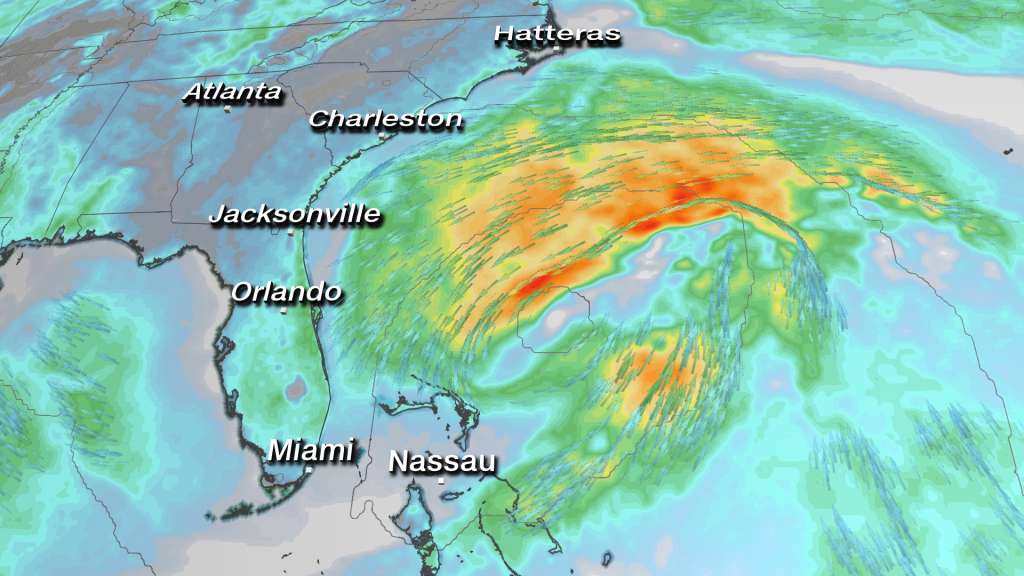
Development is likely to happen just northeast or right over the Bahamas.
As the storm gets its act together it could come close to the East Coast early next week before getting pulled back out into the Atlantic Ocean.
The most significant threats to land will be probable tropical storm-force winds, heavy rainfall and dangerous surf.
“If the system were to develop, it would likely be a subtropical depression or subtropical storm,” CNN meteorologist Dave Hennen says. “A subtropical storm is a hybrid between a regular area of low pressure (cold core) and a purely tropical system (warm core).”
The NHC began giving subtropical storms a tropical cyclone name in 2002.
For a subtropical storm to become a hurricane, it has to become fully tropical by establishing a warm core and then strengthen to hurricane-force winds.
“This potential storm is not likely to become a full hurricane,” CNN meteorologist Chad Myers says. “Still, with ocean temperatures above normal most of the year, the middle of May will likely become the new start of tropical storm season.”
Conditions are becoming favorable for tropical development
Sea surface temperatures continue to remain above average across the Atlantic — except for the cooler North Atlantic.
Warm surface temperatures are the fuel needed for hurricane development.
“Although the eastern half of North America has been cold the last few days and coastal waters are cooler than normal, the offshore area of likely development is still 2 degrees above normal,” Myers says.
It is these sea surface temperatures and the possibility of La Niña forming that have most seasonal forecasters calling for an active, possibly even extremely active, Atlantic Hurricane season.
La Niña is the cool phase of the El Nino-Southern Oscillation (ENSO) climate pattern — a naturally occurring phenomenon that involves fluctuating ocean temperatures in the Pacific.
La Niña is the opposite of El Niño, which is the warm phase of the cycle. If La Niña forms in the Pacific, it can significantly increase the number of hurricanes in the Atlantic because it creates a more favorable wind environment.
There are over a dozen early forecasts published. And even though the official forecast from the National Oceanic and Atmospheric Administration won’t come until May 21, a strong consensus in the forecasts across the industry indicates the Atlantic is in for an active season.
This could be the sixth consecutive year with a storm forming before June 1 — the official start of hurricane season.
The-CNN-Wire
™ & © 2020 Cable News Network, Inc., a WarnerMedia Company. All rights reserved.