A messy storm system has arrived in New England and is expected to leave up to half-a-foot of snow across parts of northern Massachusetts and New Hampshire over the next 24 hours.
Before the snow, though, heavy rain and sleet have been falling across Mass. due to temperatures hovering above freezing throughout New England. Due to the potential for slippery travel conditions, a Winter Weather Advisory has gone into effect for most of the state, as well as Vermont and New Hampshire.
The advisory will continue into Friday, with 3-6″ of snow on the table for most of far northern Mass., including parts of Worcester County, while the Merrimack Valley and areas along Route 495 north of Marlborough could see 1-3″.
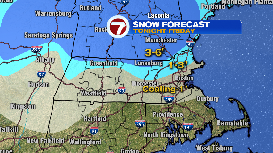
Compared to the heavy wet, snow those areas can expect, a coating of flakes that could add up to an inch is likely for the rest of Mass. come Friday, save for the Cape and South Coast.
During Thursday’s overnight hours, those spots along with Boston and most of the Route 95 corridor will see rain, though a drop of only a few degrees could turn that into mostly sleet before the system exits.
Heading into Friday, scattered snow showers will sweep through the region throughout the day. Isolated power outages are a possibility for parts of central Mass., while coastal flooding all along the North and South shores is also possible, prompting a Coastal Flood Advisory that will be in effect from 5-11 a.m.
For the latest information on the coming snow and showers, check out the 7WEATHER Weather Blog.
(Copyright (c) 2024 Sunbeam Television. All Rights Reserved. This material may not be published, broadcast, rewritten, or redistributed.)