(CNN) — A storm system that brought golf ball-sized hail and tornadoes to the South, spurred wind gusts strong enough to topple tractor-trailer trucks, and left more than 120,000 without power continues to march Friday toward the Northeast, threatening torrential rain, more tornadoes and heavy snow.
The storm system is the same that dumped feet of snow across parts of California, leaving some trapped in their homes with snow piled as high as second-story windows and prompting the governor to declare a state of emergency in 13 counties. Many of those affected are now bracing for another round of snow and rain on Saturday.
More than 60 million people are under a threat of severe storms Friday, and nearly 80 million people from Texas to Pennsylvania are under high wind alerts, including almost the entire state of Tennessee.
Damaging winds, isolated large hail and a few tornadoes could be seen from southern Indiana through Kentucky and Tennessee and into northeastern Alabama and northwestern Georgia. The regions are under an enhanced risk for severe storms that could be more widespread and occasionally intense.
Regions on the fringe of the enhanced storm risk area — such as Ohio, central Georgia and Alabama — may see damaging winds and isolated tornadoes as they face a slight risk of severe storms.
Nearly 25 million people are under flood watches from Oklahoma to Ohio, where there is a slight risk of excessive rainfall. The strongest storms could bring 1 to 2 inches of rain per hour.
As the storm pushes northward, it “will produce a swath of heavy snow from the Upper Midwest through New England Friday and Saturday,” the National Weather Service said. “Significant sleet and freezing rain is possible just south of the heaviest snow.”
As much as a foot of snow could be seen in parts of New York and New England.
The storm could bring snow and ice to cities including Chicago and Detroit.
Weather brings tornado watch, flood warnings
The Storm Prediction Center issued a tornado watch for more than 5 million people across portions of northern Alabama, northwestern Georgia, eastern Tennessee and far western North Carolina until 5 p.m. ET. The watch includes Birmingham in Alabama, Chattanooga and Knoxville in Tennessee, and Cartersville and Carrollton in Georgia.
The main threats include a few tornadoes, scattered wind gusts up to 80 mph, and isolated quarter-sized hail.
A “fast-moving [line of storms] will spread east-northeast from middle Tennessee and northwest Alabama with damaging winds and embedded tornadoes as the primary hazards,” the storm center said.
Flash flood warnings stretch about 400 miles across portions of Arkansas, Tennessee, Missouri, Illinois, Kentucky and Indiana. Most of the warnings will remain in effect through the morning.
Widespread rain totals of 3 to 5 inches have fallen across this region since Thursday night, and 1 to 3 inches more possible through today.
Meanwhile, flood watches are also in effect for more than 20 million people from Arkansas to Ohio.
“Prolonged heavy rainfall rates associated with training showers and thunderstorms may also lead to flash flooding throughout much of the Mid-Mississippi and Ohio Valleys stretching eastward into the Mid-Atlantic,” the Weather Prediction Center said Friday morning.
Tornadoes spotted Thursday
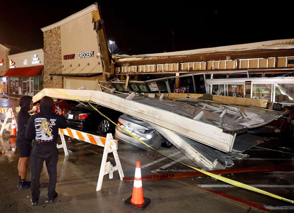
In Texas, Louisiana and Alabama, the storms damaged homes and businesses and caused flight disruptions at airports Thursday.
Six tornadoes were reported during Thursday’s storms, including five in Texas and one in Louisiana, where dozens of homes were damaged in the city of Shreveport. Across Texas and Oklahoma, there were 18 hail reports, with the largest hailstones reportedly 1.75 inches in diameter, or roughly the size of a golf ball.
About 120,000 people in Texas were still without power early Friday, according to outage tracker PowerOutage.us, including about 8,000 people in metro Dallas-Fort Worth’s Collin County, where winds were strong enough to knock over four 18-wheel semi-trucks, causing portions of a highway to be shut down, police said in a tweet.
Power was restored to medical facilities west of Fort Worth in Weatherford, Texas, where more than half the city was initially without power and many homes, businesses and the city hall were damaged, said city spokesman Blake Rexroat.
Snow-buried California communities brace for another round
After a brief reprieve from back-to-back winter storms that have brought unseasonably cold temperatures and prompted rare blizzard warnings in parts of the state, northern California is expecting another round of snow beginning Saturday.
By the end of the weekend, 1 to 5 feet of snow is possible across some northern areas, including the Sierra Nevada mountain range.
But many communities blanketed by the last round of snow have yet to recover as snowfall blocked critical roads, trapped them in their homes and damaged vital businesses such as grocery stores.
An 80-year-old woman, Lois Barton, died in a “weather-related” incident in Placer County, county sheriff’s office spokesperson Angela Musallam told CNN. She did not share the circumstances of the death, though where the incident occurred saw heavy snow and temperatures around freezing on Tuesday, CNN meteorologists said.
Gov. Gavin Newsom issued a state of emergency in 13 counties this week, including hard-hit San Bernardino County where the National Guard arrived Thursday to assist with rescues of snowbound residents.
A number of structure fires in San Bernardino County appear to be storm-related, the county fire department told CNN. The department said the number of fires is “atypical” but did not provide an exact number.
Fire officials are investigating the cause of the fires and working closely with local utility companies, county Fire Battalion Chief Mike McClintock said. CNN has reached out to Southern California Gas Company, a major provider in the area, on reports of gas leaks.
In the San Bernardino community of Crestline, residents have been immobilized by the copious snowfall and have started to become worried about access to supplies as their sole local grocery store has closed after its roof caved in from heavy snow, resident Paul Solo told CNN.
Nearly 100 inches of snow have fallen on Crestline and nearby Lake Arrowhead in recent days. Aerial footage from CNN affiliate KCAL shows neighborhoods with indiscernible streets and homes with snow piled to second-story windows.
The only way to get around is by shoveling walkways for emergency exits, Solo said. He added, “Everyone every day has been shoveling, and then it’ll snow another two feet.”
Solo believes it could be another week or two before the snow is cleared.
“Until then, we are trapped in our house. We couldn’t even leave if we wanted to.”
(Copyright (c) 2024 CNN. All Rights Reserved. This material may not be published, broadcast, rewritten, or redistributed.)