(CNN) — Record December heat surging northward to Canada is fueling severe weather across the central US Wednesday, creating hurricane-force winds, potentially strong overnight tornadoes and an extreme fire threat.
“Another historical weather day is forecast today with 2 never-before-seen outlooks issued,” the National Weather Service tweeted. A moderate severe storm risk is in the Iowa, Minnesota and Wisconsin region, while the severe fire risk is over the Southern and Central Plains. This is the first time such risks in these locations have ever been issued in December.
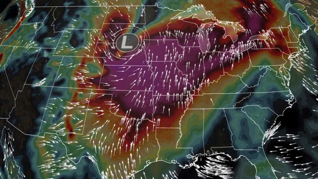
The system that has already been responsible for several feet of snow, as well as hurricane-force wind gusts in the West, now has its sights set on the Plains and Upper Midwest.
‘Unprecedented’ severe storm threat looms
More than 20 million people could experience severe weather, including strong tornadoes and hurricane-force winds today, after last week’s tornadoes left parts of Kentucky in shambles.
A moderate — level 4 of 5 — threat covers parts of the Upper Midwest, where another round of widespread severe storms and tornadoes is expected later today and tonight, according to the Storm Prediction Center.
The greatest risk is located south of Minneapolis and includes nearly two million people in Minnesota, Iowa and Wisconsin.
“This threat appears unprecedented for this region this late in the year,” the prediction center said.
“There has not been a moderate risk issued in Minnesota between the months of November and February, according to records dating back to 1987,” said CNN meteorologist Brandon Miller.
Widespread wind gusts of 60-75 mph and tornadoes are forecast. A derecho, or widespread damaging wind event, is possible this afternoon and evening with “embedded gusts of 80-100 mph,” the prediction center warned.
The most dangerous time frame will occur from late this afternoon through sunset and could include nighttime tornadoes. Like the tornado outbreak on Friday and Saturday of last week, much of the activity is expected after dark, when tornadoes are 2.5 times more deadly.
“A nocturnal strong tornado or two are possible, particularly across western to northern Iowa and southeast Minnesota,” the prediction center added.
Fueling these storms is record heat much farther north than expected this time of year, with dozens of record high temperatures expected to fall today.
The unusual December warmth has expanded across a large area of the eastern US, with as many as 250 record temperatures possible from Wednesday to Saturday, according to the National Weather Service.
Minneapolis is forecast to reach the mid-50s Wednesday when the average high temperature is below freezing.
This heat and powerful storm system is also creating an extreme fire threat in the Central Plains on Wednesday.
Hurricane-force winds and extreme fire danger
More than 80 million people are under wind alerts Wednesday, as the same powerful storm system brings hurricane-force wind gusts (74+ mph) to much of the central US.
“We’re very concerned here in western Kansas. This storm has some of the strongest wind values we’ve seen in many years, as predicted by our computer models,” said Bill Turner, lead forecaster with the Dodge City, Kansas, National Weather Service, told CNN.
The concern is not just isolated to the Plains. Strong winds causing hazardous travel conditions will spread across a 1,500 mile stretch of land, as sustained winds of 20-40 mph could be felt from parts of Arizona to Michigan.
Wind gusts could reach 80 mph in some locations, where extremely dry soils and unusually warm December temperatures are colliding to set the stage for extremely dangerous fire conditions.
“Out here in the High Plains, there’s nothing left that’s green. All the grass is brown and dry and ready to burn,” Turner told CNN.
In parts of the Texas and Oklahoma Panhandles, along with western and central Kansas, the Storm Prediction Center has issued a rare level 3 of 3 alert. The center warned that “very dangerous wildfire-spread conditions are expected” in these areas.
“We haven’t any precipitation here in a long time,” Turner said. “We have gone 42 days since we’ve had measurable precipitation, so the grass is dormant and dry and can take a spark very quickly.”
On Tuesday, record highs fell by the wayside in Texas as highs soared past 80 degrees in cities including Houston. Temperatures reaching into the 70s will spread as far north as Kansas City on Wednesday.
That warmth, coupled with gusty winds and relative humidity below 10%, could make Wednesday a potentially destructive day for millions in the region. On Tuesday, the National Weather Service in Dodge City alerted fire departments of the looming threat.
“We gear them up and make sure they know what the potential threat is. We are all hoping we can get through Wednesday with no ignitions,” Turner added.
In eastern Colorado, temperatures are not nearly as warm, but given the dry landscape, low humidity and fierce gust forecasts to reach as high as 75 mph, any spark could be disastrous.
“We have fire season 24/7 and 365 days across Colorado, and since summer and late fall, we have seen very dry conditions and that has ramped up our fire situation now,” Mark Wankowski, meteorologist at the National Weather Service in Pueblo, Colorado told CNN.
In eastern Colorado and western Kansas, drought conditions range from severe to extreme according to the US Drought Monitor, adding an additional threat to the interstates in the region.
“There’s also a potential for blowing dust and dirt because of our current drought conditions,” Wankowski said. Travelers across Interstates 40 and 70 could be greeted by periods of blowing dust, haze and dangerously low visibility on Wednesday afternoon.
In the Texas Panhandle, the ground is akin to a tinderbox, with months having passed since the last drop of rain fell.
“Our last measurable precipitation for Amarillo was back on October 12, so we have been dry over 60 days and that’s definitely contributing to the fire risk,” said Luigi Meccariel, meteorologist at the National Weather Service in Amarillo.
“The combination of very dry and windy conditions is going to be very dangerous for outdoor activities. We definitely don’t recommend any activities that could cause a ground spark and start fires for Wednesday,” Meccareil added.
The region typically experiences significant fire weather in the spring season, but given the record warmth and the recent dry spell, things look a bit different this year.
“It’s a very unusual day in December by any stretch of the imagination, but as you’ve seen the past week, we’ve had some very unusual weather in the US,” Turner said.
The-CNN-Wire
™ & © 2021 Cable News Network, Inc., a WarnerMedia Company. All rights reserved.