Happy Saturday!
Growing up with a family from East Boston, the phrase “mezza mezza” was nothing short of being overused! So when someone asks me, “how does the weather look this weekend?” I’ll say to them, “mezza mezza, half looks good, the other half, not so good!”

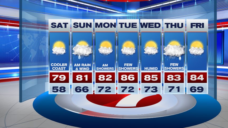
Today certainly will be the “pick of the weekend” with a sunny start and fading sunshine through the afternoon hours. Along with the clouds, an easterly wind off the Ocean will help keep temperatures from heating up..high temps reach the lower 80s inland, mid 70s along the coastline.

Clouds thicken up overnight along with winds on the increase out of the east/southeast as a potent low pressure system develops and hugs the coast as it tracks northward. We can expect showers to develop during the late night hours and become more numerous by daybreak as a warm front pushes through southern New England. Heavy rain, gusty winds, and thunderstorms will accompany the front and the potential is there for those storms to be strong to severe with localized flooding. Though very low, the threat for an isolated tornado is also in play from southern and eastern Connecticut, eastward through Rhode Island, and southeast Massachusetts. Much of the action exits by the early afternoon as the warm front lifts northward, however, still keeping the threat for a shower, downpour, or t’storm in play through the evening into Sunday night.

Muggy and warm conditions will be with us throughout much of next week with the shower and thunderstorm threat as well as we find ourselves in a tropical like air mass courtesy of high pressure over the Atlantic. Crank up the A/C’s, the “muggies” are back…
Enjoy your Saturday!
David
(Copyright (c) 2024 Sunbeam Television. All Rights Reserved. This material may not be published, broadcast, rewritten, or redistributed.)