
Well… just like that we’re a quarter of the way through 2021 as we welcome April tomorrow. So before we get to the forecast for tomorrow, what has April brought us the last few years? Well, a little bit of everything!
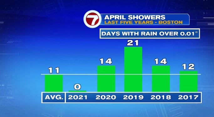
Let’s start with rain. The last four Aprils have provided a lot of it. The first graphic here is just the NUMBER of days in the month that featured any sort of measurable rain. Yes, it could be one little spot shower, or maybe during the overnight hours, but regardless the number of days that featured rain have been above average the last four years.
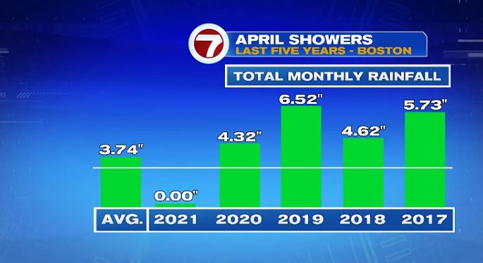
If you take the number of days with rain, it wouldn’t necessarily mean above average rain. You could have several days of light rain which added up to an average amount. But that still wasn’t the case. The last four years featured rainfall tallies well above the average. Which this year wouldn’t be a bad thing to help us catch up in our rainfall deficit.
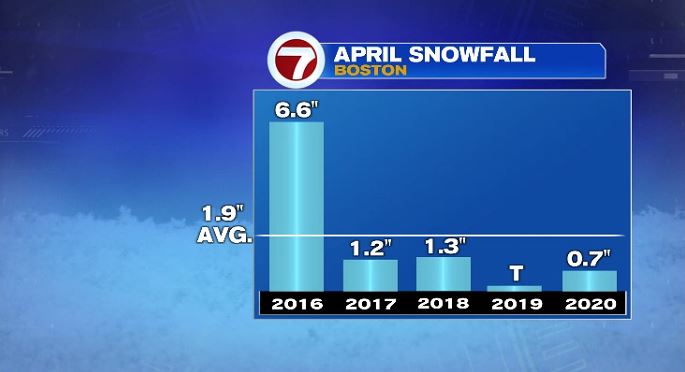
What about the thing that nobody wants to talk about?… snow! Well we do typically see at least SOME snow in April. On average it’s less than 2″ over the whole month. Just eyeballing the last few years, we’ve had closer to 1″. That said, 2019 was nothing more than a few flakes with 2016 giving us over a half a foot!
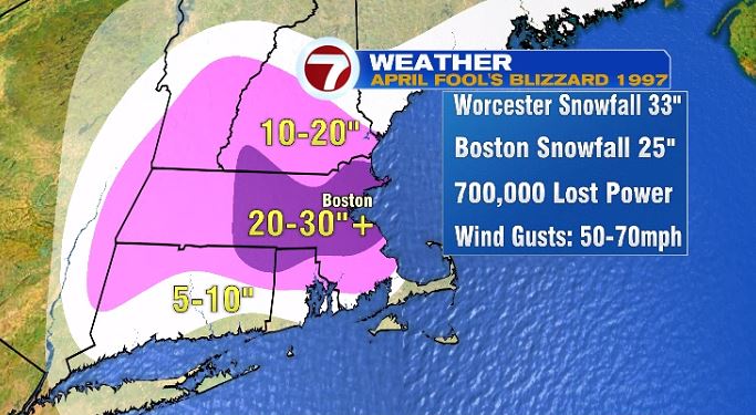
And a sidebar about April snow here… Remember 1997? If not, I’ll leave you with this graphic and walk away. This was the April Fools Day Blizzard in 1997. Yikes!
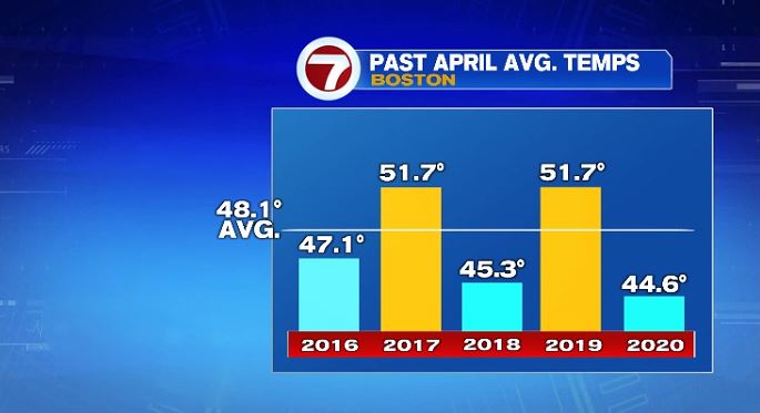
So back to past Aprils. What about temperatures? Well this one is hard to generalize. It really can be anywhere. We’ve had years that ended up well below average and years that have been well above average. In this case, let’s just hope this nice pattern on the graphic continues with alternating cold and warm Aprils because in that case we’d be in line for a nice warm one! **This is not a forecast! It’s just looking at the pattern and wishful thinking!
Now the forecast for tomorrow, the first day of April! You know how the saying goes. April showers bring May flowers. And we’ll kick off the month with showers. They actually will start late tonight and continue into tomorrow morning. Once we dry out, we’ll stay that way Friday and Saturday. Easter Sunday looks like just a few sprinkles to press on with those outdoor Easter egg hunts!
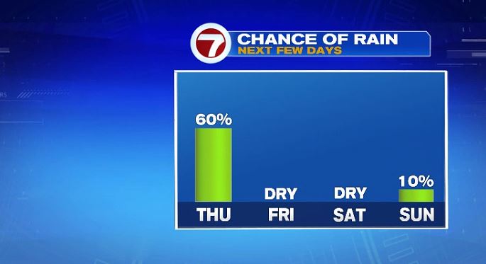
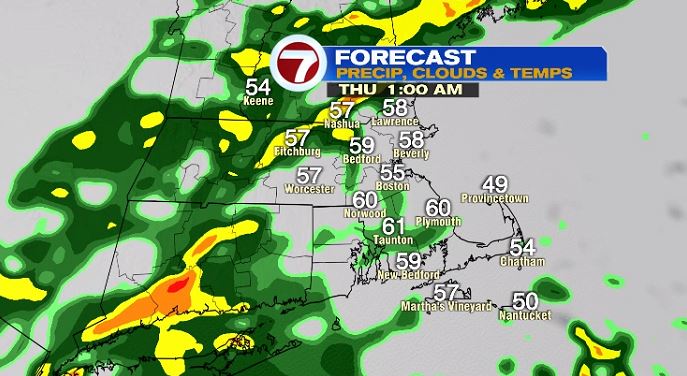
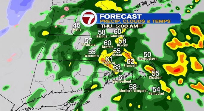
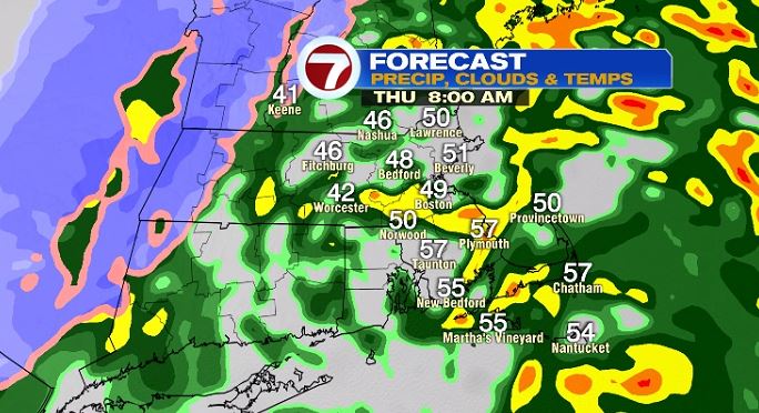
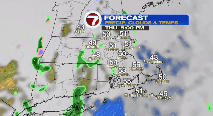
Here’s a timeline of the rain below. Notice by 8pm tonight, a few sprinkles or a spot shower. It’s not until after midnight when showers will fill in. But we’ll have scattered showers into tomorrow morning, until about lunch time. So plan on a wet morning commute on Thursday morning. Once we head past lunch time we dry out significantly. That said, our rain chances don’t go to zero. We could see a few sprinkles or a spot shower, but notice how much less the chance is for the afternoon hours tomorrow.

So what does that mean for the Sox game? Well it’s not a washout! Seats and the field will be wet but falling rain chances will be at a minimum.
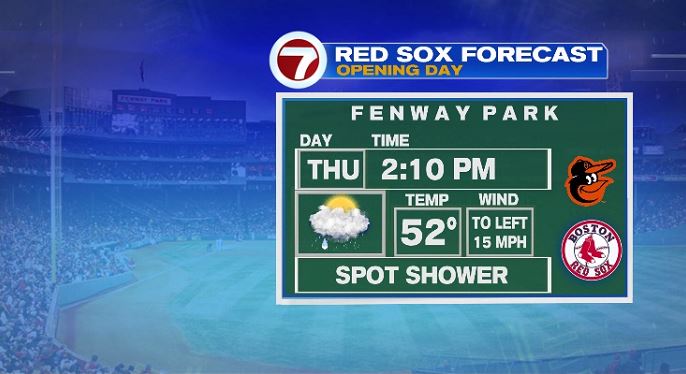
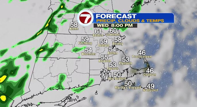
Tomorrow’s forecast as a whole will be cloudy with morning showers. Winds will be a little gusty at times with west winds gusting up to 25 mph. While clouds linger all day, showers will mainly be confined to the morning hours. And note the temperature range… that’s not a typo. Temperatures will start in the upper 50s to near 60 in the morning with the rain. As we dry out, temperatures will fall to near 50 for the afternoon.

The rain we’ll get is much needed and many towns, between late tonight and midday tomorrow, will add nearly an inch of rain to the backyard rain gauges.
