It took longer than normal but Boston-Logan finally reached 90 degrees for a high temp on Friday afternoon.

Akin to that first inch of snow during the winter months, sooner or later, it simply had to happen. On average, the first day Boston-Logan reaches 90 degrees is May 31st…some years earlier than that and others years like this year….later. This year was unusually late tho. The latest date Boston-Logan reached 90 was July 30th back in 1947.
This year slots in at #7. Will tomorrow be day number 2 of 90 degrees? It will be close as we will have a cold front ramming into the heat & humidity by late afternoon. Before the front arrives, temps will get close to 90 and it will be more humid (dewpoints over 70 degrees) than recent days. Tomorrow is an uncomfortable day when outside.
The other concern tomorrow is the threat for scattered strong thunderstorms. I don’t think storms foul up outdoor plans before 3pm but after that, all bets off. This map tries to time out the storm threat…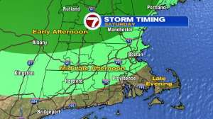
Keep an eye on those storms thru our 7 weather app (shameless plug, I know) as a few of them will be feisty!|
Some of the storms could be severe across Maine and New Hampshire. The good news is that these storms are tied to a cold front and that front will do wonders to our weather by Sunday. MUCH less humid, cooler and a nice refreshing breeze throughout the day. Looking into early next week, some great summer weather on tap before it starts to heat up again.
Be safe and enjoy the rest of your Holiday Weekend!
~JR