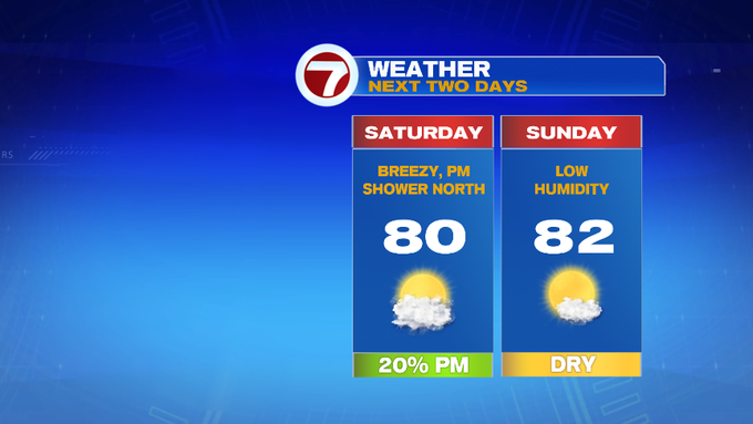
We’re tracking a mainly dry Saturday…we say “mainly” due to the fact that most of the day will be dry, but a spot shower may pop up in the afternoon. These will not be long lasting and these will not be widespread.
This morning, we woke up to gorgeous conditions, refreshingly lower dewpoints (dare say that it almost felt like fall when I walked into work this morning). The lower humidity will continue to stick around through the weekend.
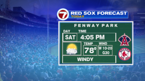
For your Saturday outdoor plans, besides a spot sprinkle in the afternoon, it’s looking nice. It will be gusty at times though, so hold onto your hats. Gusts could top out near 30 MPH. For the second weekend of August, I know many are trying to soak up the last bit of summer as they can. Below is the beach forecast, a look at the Fenway forecast and a forecast for concert-goers heading to the Jimmy Buffett concert later this evening:


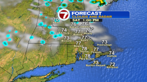
Now for timing of hit or miss showers for this afternoon. Between 1pm – 5pm and most of these will remain north of the Pike.


Sunday is the better half of the weekend because we have calmer winds, the humidity is still low, AND we have ample amount of sunshine. It will be a little cooler in the morning, with the overnight lows slipping into the 50s to around 60 into the early morning hours.


Temperatures will quickly rebound, with highs into the low 80s by tomorrow afternoon.

For the work week, the heat returns Monday, but the humidity will still be at somewhat comfortable levels. Tuesday and Wednesday is when we see the return of widespread showers and storms. As far as timing, it looks like Tuesday afternoon and evening for scattered thunderstorms, with of a few embedded heavy rain. Showers linger into early Wednesday before drying out and cooling off into the 70s for highs for the end of the week.
