Not only is the heat and humidity dangerous, it’s also tied or even broken some long-standing records as early as this morning.
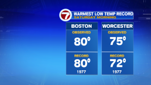
The overnight low only retreated back to 80 in Boston, 75 in Worcester. Boston tied the record hottest low set back in 1977, while Worcester set a new record, surpassing it’s old record of 72 set back in 1977.
Under a hazy sunshine, temperatures this afternoon will continue to soar, close to triple digits in Boston, with quite a few spots likely reach 100°.

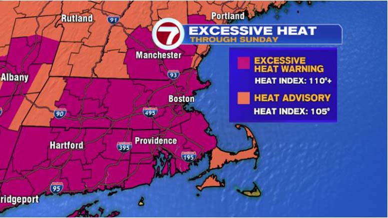
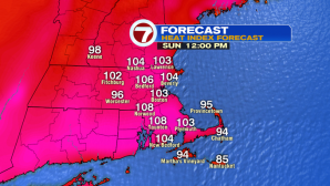
Now, the heat index (both today and tomorrow) is why the Excessive Heat Warning is in effect…both Saturday and Sunday, the “feels like” temperature will be between 105-115°. A Heat Advisory has been implemented for Cape Cod and Martha’s Vineyard for heat indices nearing 105°.


Be sure to take plenty of water breaks if you have to work outdoors today (or tomorrow), and seek the shade if at all possible. Also, check on the elderly and those without air conditioning. Also, don’t forget about your pets (especially with the hot pavement adhere to the 7 second rule: if it’s too hot for your palm, it’s too hot for your furry friends to walk on).
Sunday features a few more clouds and a chance for afternoon thunderstorms, but these will be very spotty, not everyone will see these storms. UV Index very high both today and tomorrow, a few more clouds and showers in the forecast Monday, lowering the UV Index to 8.
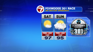


Overall, Sunday will be the third day in a row of at least 90+ temperatures, completing our heat wave for most of southern New England.

As we turn the page to the next work week, highs on Monday will be lower, but it will still be quite muggy. We finally usher in a new weather pattern Tuesday and Wednesday, with highs into the upper 70s and dewpoints falling to near 60.

As for rain chances, Monday features scattered showers with just a few lingering showers Tuesday.
Thursday and Friday are back to seasonable (low to mid 80s) under mostly sunny skies.
