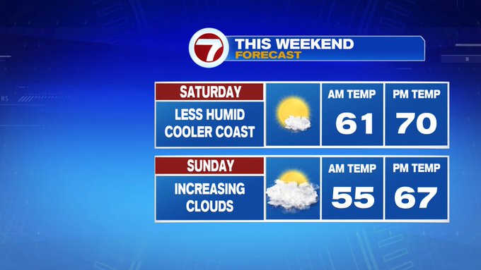
The strong to severe storms that rolled through late last night has since moved out, leaving behind a comfortable airmass and mainly sun-filled skies for our Saturday, which is good for any of that storm damage clean-up needed around your yard, just don’t forget the sunscreen if you’re spending time outdoors today.

Today, we’re tracking highs into the low 70s, especially inland, cooler at the coast due to an onshore breeze that develops later this afternoon, dropping the temperatures at the coast into upper 50s to low 60s.


This evening, it’s our first 8PM sunset of the year and we’ll see mainly clear skies for it, allowing temperatures to quickly drop after sunset. Overnight lows slip back into the 40s, cooler than the last few nights.

Tomorrow, we’ll see increasing clouds with highs into the mid to upper 60s, which is seasonable for this time of the year.
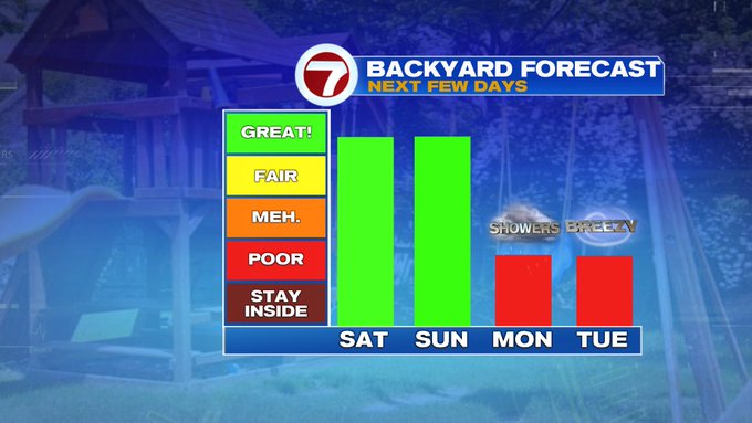
A colder pattern kicks in for the start of the work week. Both Monday and Tuesday we’ll see mostly cloudy skies, with coastal wind keeping the temperatures only into the 50s for highs both days.

Monday features the better chance for showers through the early afternoon associated with a system over the Midwest. We’re keeping an eye on a cluster of thunderstorms just off the eastern coast of Florida, which could form into the first named tropical system of the year (ahead of hurricane season, which begins June 1st). If this system forms this weekend, it will be the 6th year in a row that we see a named storm ahead of hurricane season.


This system, named or not, will continue to climb up the eastern seaboard, which could churn up our seas, but also enhance the wind felt at the coast both Monday and Tuesday.

A high pressure system just to the east of Maine will block both the system just off to our west and the offshore system from moving northbound into southern New England- making for a drier Tuesday and Wednesday compared to previous forecasts.
A warm-up returns by the end of the week.
