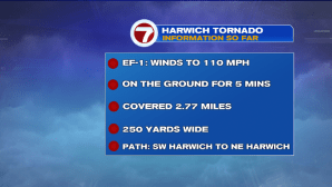
After yesterday’s downpours and severe weather, it was the calm after the storm for the day today, allowing for those affected on the Cape to clean up and for the National Weather Service (NWS) to assess the damage to estimate the strength, path length, and width of tornadoes that touched down on the Cape Tuesday.
According to the NWS, two tornadoes caused the damage on the Cape yesterday. One tornado touched down from Barnstable to Yarmouth, for 10 minutes, boasting 110 MPH winds – a high-end EF-1. This same storm system spawned another high-end EF-1 tornado, lasting about 5 minutes, traveling over 2.5 miles, from SW Harwich to NE Harwich.


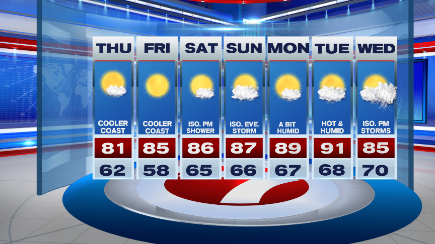
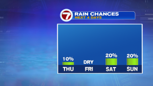
High pressure takes over through the end of the week, providing calm, comfortable and dry conditions. Overnight tonight, under mostly clear skies, temperatures will slip back into the upper 50s to low 60s, great for turning off the AC and opening up the windows.

Thursday features very similar conditions to the day today. High temperatures will reach into the low 80s inland, near 80 at the coast due to an onshore breeze.

Friday gets slightly warmer along with slightly higher dewpoints.
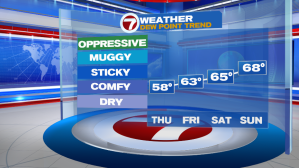
We’re in for a weekend warm-up with highs into the mid to upper 80s. With slightly higher humidity, we can’t rule out a pop-up shower/t’storm inland on both Saturday afternoon and Sunday afternoon – the bulk of the weekend hours are dry, just a spot sprinkle.
We make a run for 90-degree heat by the next work week, with the next best chance for widespread showers and storms Wednesday afternoon/evening.
