

Well now that fall is really here I guess a day like today….mainly cloudy and cool…. is to be expected. If you are into this vibe then have good news for you….more of the same the next two days! Here is the weather map for Tuesday…

We will be under the influence of that blue H east of Bangor Maine. Normally, High Pressure (which is what the blue H stands for) provides a region with sunny weather but the location of that blue H is the issue. That location of the High Pressure will continue a northeasterly wind flow which will scrape moisture off the Atlantic Ocean and produce another mostly cloudy and cool day for us.

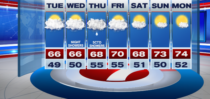
A few brief sprinkles are even possible from some of those clouds. Afternoon temps will be rather uniform, mid 60s, a bit cool for this time of year…

More of the same for Wednesday….a lot of clouds but little in the way of precipitation. By Thursday, a cool front will approach and that front will offer us our highest chance of rain for the week…scattered showers.

After the showers peel out of here, Dry weather will settle in for Friday as well as the upcoming weekend.

Fairly quiet weather ahead for the next 7 days with a bit of a warming trend by late week and into the weekend. Our weather is quiet but the big weather story of the nation will likely be a major hurricane that approaches the Florida panhandle late week.

As of Blog Post time (early Monday evening), Potential Tropical Cyclone 9 is located about 100 miles south of the Cayman Islands and is forecast to become a hurricane by Wednesday as it enters the eastern Gulf of Mexico. From there, the path of the storm would be north into the Florida Panhandle on Thursday as a Major Hurricane (winds in excess of 111mph)..

This storm will have no bearing on New England. More on this potential hurricane throughout the week.
Ciao for now,
JR