We’re finally out of meteorological spring. Boston tied the record of 50 days of measurable rainfall in the spring season. That record was set back in 1983.

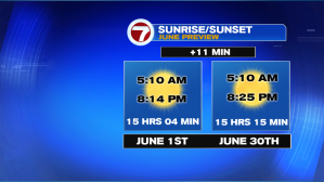
Now that we got the spring-chat out of the way, let’s chat about meteorological summer, which spans from June 1st to August 31st. At least for the month of June, we still gain daylight, with sunrises a little after 5AM and sunsets between 8:15PM and 8:30PM, this is the month for outdoor plans.
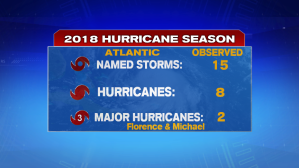
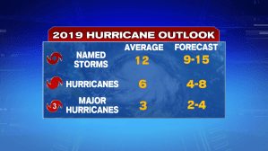
However, what also starts on June 1st is Hurricane Season. Last year, we had 15 named storms, 8 hurricanes, with two of those becoming major hurricane status (Category 3 or higher). Those two were Florence and Michael, which are now officially retired names due to their destruction and shear power.

The Atlantic Hurricane List for 2019 has already been released earlier this year and we’ve already seen our first named storm (back in May). That was Andrea, which had formed near Bermuda and was not able to survive in the cool ocean waters this time of the year.

As for predictions, below is the forecast that NOAA released a few weeks ago for this upcoming season:
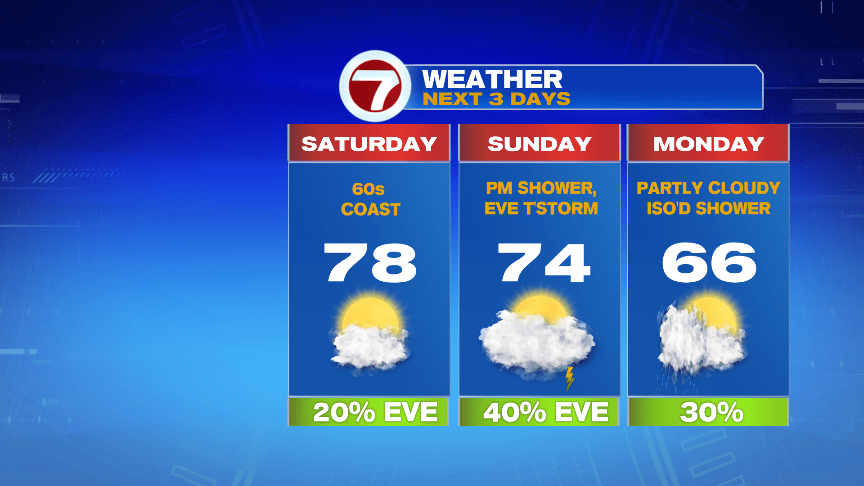
As for the forecast for the rest of this weekend and through the next work week, we do have some shower chances, but those hold off until Sunday afternoon/evening.

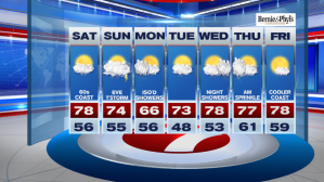
As for your Saturday afternoon, expect highs into the mid 70s inland, 60s at the coastline due to an onshore breeze and some fog that stuck around a little too long.
Clouds and fog thicken overnight into Sunday morning, so we will be waking up to more cloud cover tomorrow morning. Overnight lows only slip into the 50s.
As for Sunday, we start off dry, and that continues into the first half of the afternoon.
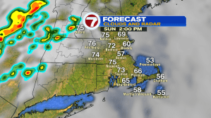
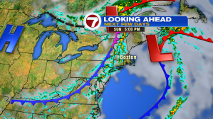
We could see a few pop-up downpours to the west, ahead of the main line of showers with embedded thunderstorms that move into southern NH, central MA between 5PM – 7PM, with Boston staying dry through at least 7PM.

Some of the thunderstorms could be on the stronger side Sunday evening, with hail and gusty winds being the main concern.

The reason for the thunderstorms? A cold front will be sweeping through tomorrow afternoon and evening. This cold front will usher in cooler and much more refreshing air come Monday, but a few showers are still possible Monday afternoon.

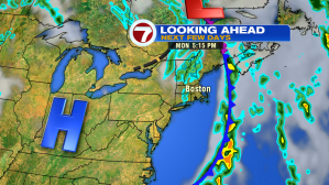
Tuesday is drier and seasonable. Wednesday features night showers lingering into Thursday morning, while Friday looks to be the pick of the work week with highs into the mid 70s under mostly sunny skies.