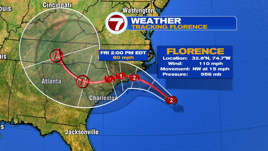
Not a whole lot has changed in the forecast of Hurricane Florence overnight from the National Hurricane Center in terms of impacts, location, and timing. Yes, Florence has weakened a bit, but I wouldn’t spend too much time focusing on that. Florence is a large hurricane with an expanding wind field, capable of producing a large storm surge of 9-13 Feet. In addition, the rain forecast has remained unchanged too as the potential for locally 30″+ of rain is there over parts of southeast North Carolina. That would crush the state record from hurricane Floyd. The South Carolina record may fall too. So despite some fluctuation in strength, the message remains the same… This will likely a very damaging blow for the area between a destructive storm surge, damaging hurricane force winds, and potentially catastrophic flash flooding from rain.


In terms of our weather, showers and storms early this morning fade out and as high pressure builds in, we improve our weather. The weekend looks great with temps near/above 80 inland and 70s at the coast. If you’re heading to the beach just be careful of some rip currents and rough surf along the south facing coasts. If we get moisture from Florence, it would be until Tuesday night/Wednesday. We’ll keep an eye on the evolution of that, as a quick back of 2-5″ of rain may set up somewhere in New England. Whether it’s here on in northern New England, remains to be seen.

Have a good day.
@clamberton7 -twitter