
If you were a fan of today’s summery weather, Friday features mainly sun-filled skies with highs into the 80s. It will be quite breezy at times, especially into the afternoon.
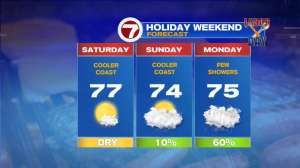
Looking ahead to your Labor Day Weekend, the unofficial end to the summer season, highs will be into the low to to mid 70s from Saturday through Monday.
However, for Labor Day, we do have a chance for some showers, but there will be some dry times to get some outdoor time in with friends and family.
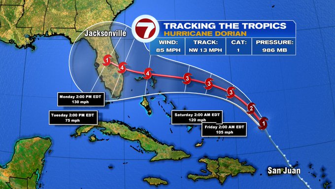
If you have family, friends, or property down in Florida, you probably have kept an eye on the forecast for Hurricane Dorian. As of the 5PM update on Thursday evening, Dorian still continues to track northwestward at 13 MPH. The storm continues to intensify to a Cat. 2 by late tonight and continuing to strengthen to a major hurricane (Cat. 3+ by early Saturday).
The cone of uncertainty spans from South Florida to southern GA by early Monday with the hurricane continuing to strengthen to a Cat. 4. As always, we will continue to give you the latest updates on Dorian as it approaches the US coastline.
Sunshine returns into Tuesday with highs around 80 as everyone heads back to work/school. Low 80s with some humidity sliding back in, allowing for a chance of showers on Wednesday, out to the northwest. Then, cooler conditions slide in by next Thursday with highs into the low 70s.
