It’s been a while since we’ve chatted…..glad to make a cameo in the blog-o-sphere! Another hot day for folks inland but along the coast a sea breeze stopped the Heat Wave in its tracks! Map shows afternoon high temps…

Thankfully, even inland, the dewpoints were only in the low 60s..making it more of a dry heat. July is, on average, our hottest month of the year and this year is no different with the monthly average nearly 2 degrees above normal!
For the year, Boston has had a high temp of at least 90 degrees 8 days with 7 of those days happening in July. As for tomorrow (and beyond) we don’t have any excessive heat or humidity but we do have typical warm/hot weather ahead. We also have the risk of some afternoon thunderstorms tomorrow thanks to Low Pressure up in Canada.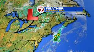
Now….the Low itself won’t pester us but you see those dashed black lines attached the the Low? Those are elongated areas of Low Pressure…think of the whole setup as a bicycle wheel…and those dashed lines are the spokes of the wheel…..when those spokes move through, they spark some isolated storms.
That is what the radar probably looks like tomorrow afternoon…..isolated! Meaning most towns are likely dry but there will be a few hit-n-miss storms dancing across southern New England between the hours of 1-6pm. No washouts. As for the next several days….

A few showers Friday morning south of the Pike then partly sunny skies with a decent weekend shaping up! Early next week (thinking Tuesday-ish at this time) we will have to watch what comes out of the tropics. As of this evening, that area of tropical weather is located across the southern Caribbean…

Which doesn’t have a name yet but when it does, will be called Isaias and track toward Florida this weekend. It’s possible that remnant moisture from that storm may find its way into New England early next week…more on that by the weekend.
Enjoy these last few days of July…here comes August.
~JR