We started off with some clouds earlier today ahead of a seabreeze that eroded the clouds, allowing for mainly sunny skies this afternoon.
We likely remain dry through the evening and overnight, with a stray shower possible into southern NH possible late tonight as some remnants of strong t’storms off to our northwest try to move in, but dissipate and fall apart before even reaching central MA/Monadnock Region.
Tonight, patchy fog is expected as temperatures only slip into the upper 50s to low 60s.

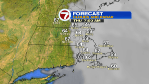
Tomorrow, we still remain dry, but we start off very similar to earlier today. Clouds linger for the early morning commute (~7am), then that cloud cover will erode as the June sun-angle eats away at the low level clouds. A slight onshore breeze will keep temperatures slightly cooler at the coast tomorrow, otherwise inland stretches into the low to mid 80s.

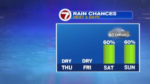
Dry conditions stick around through Friday, before rain chances (well, thunderstorm chances…it is summer after all) returns to the region. Don’t cancel your outdoor plans just yet, but there’s scattered thunderstorm chances both weekend days, but it does not look to be a washout, definitely something to keep an eye on as we get closer.
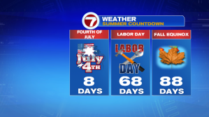
Speaking of getting closer, the Fourth of July is ALMOST in the 7-day forecast (is it just me, or did June just FLY by?). We will continue to keep an eye on the Fourth and on the following weekend for your outdoor plans. Stay tuned.