Two months ago a powerhouse nor’easter was pummeling southern New England with heavy snow, high winds and coastal flooding. #TBTBombCyclone We have another nor’easter slated for today and tonight night and while they are similar in nature this one will do a real number on our shoreline. Main reason being a slower moving storm. The Cyclone came ripping through here in about 12-15 hours while this one will slowly pass south of New England in about 24 hours—actually doing a small loop southwest of Nantucket this afternoon!
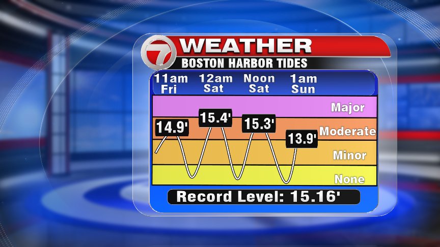
The greatest concern is still for coastal flooding–not just one high tide cycle but three! This graphic is from the National Weather Service and it is a great graphic loaded with information.
of course, if it’s a storm, then we must be talking heavy precipitation and no different with this one. Rain will arrive before the Friday morning commute gets under way and pick up during the morning hours, with 2-3″ of rain possible for most of eastern and central Massachusetts. SE Mass. could see a few 4″ rainfall totals as well. Urban flooding and some stream flooding is possible, and Flood Watch is effect across E. Mass.
with 2-4 inches of rain likely in the green shaded areas. Other locations can plan on 1-2 of rain—even in the Worcester Hills. The storm will have to make its own cold air (and it will) so we all start with rain this morning but by afternoon, enough cold air begins to seep out of the upper levels and flip the rain to snow. Exactly when will be tricky, but I think between 3-6pm. For a few hours it will snow heavily but not for everyone–best chance will be the farther from the coastline you are. All precipitation tapers tomorrow evening, in fact, once the snow intensity lets up it will likely flip back to light rain/drizzle. Here is the snowfall forecast:
For those of you in Worcester county, towns with elevations around 1000 feet (Gardner, Ashburnham, Rutland, Princeton) should plan on 8-12″ of a heavy, wet snow. Poor travel is likely in the blue shaded regions, where in the white shaded region (1-4″) roads should be warm enough to keep them wet.
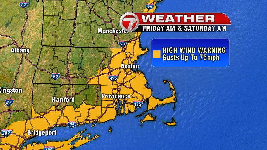
Winds will be incredibly strong across the coast today, with sustained winds out of the northeast of 35-45mph, and gusts upwards of 60 mph. Cape, Islands and (and potentially Cape Ann) could experience peak gust of 70-75 mph.

We already have a handful of power outages as of 8AM this morning, and unfortunately, we’re going to continue to see many power outages as winds ramp up this afternoon. Peak winds will be this afternoon through about midnight tonight.
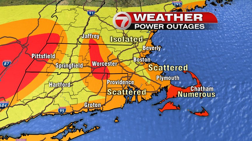
That wet snow, combined with these strong wind gusts likely means power disruption is likely. Charge up those mobile devices tomorrow morning! Be safe tomorrow-early Saturday—we’ll have continuing coverage throughout the storm.