Today makes three days in a row of at least 90-degree high temperatures, as of 11am Sunday morning.
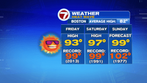
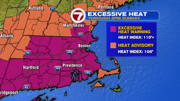
It will be another hazy, hot and humid day with highs stretching to 99° in Boston, with a few other spots nearing 100 this afternoon. The Excessive Heat Warning continues to remain in effect for most of the Bay State and around Manchester, NH through 8PM this evening. The heat index is expected to yet again climb between 105-110 today.

It’s another day to be sure that you stay hydrated, take plenty of breaks if you are working outside for an extended period of time, and be sure to check on the elderly and those without air conditioning.

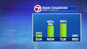
A few pop up showers are possible today, but these will be very spotty and not everyone will see them. Tomorrow afternoon is when we see the return of scattered showers.
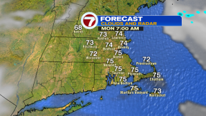
Even more good news. Relief is on the way, but it will likely not arrive until Monday morning…in the form of cooler temperatures (and slightly lower dewpoints). We wake up tomorrow morning to mainly clear skies and temperatures ranging from the mid 60s to low 70s.
By the afternoon, highs only reach into the low 80s, and it will get muggy ahead of rain showers and embedded downpours that slide in between noon and 3PM.
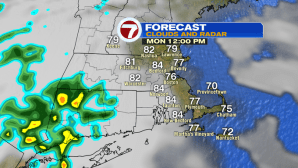

Monday will not be a washout, but we’ll likely periods of rain through the afternoon and into the evening. A rumble of thunder cannot be ruled out, but a few of these downpours will be tropical-like.

We have lingering showers into Tuesday, through at least mid-afternoon, but the clouds stick around through most of the day. The big story about Tuesday are the highs…only into the mid 70s! How refreshing does that sound?!
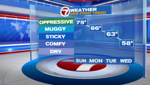
We stay into the 70s Wednesday under partly cloudy skies and low humidity. The end of the week brings back seasonable highs and mainly sun-filled skies. Temperatures start to warm up into the next weekend.
