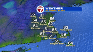
This morning’s lows started off in the low to mid 50s for southern NH, Worcester Hills and the Merrimack Valley. Boston was one of the warmest spots at 62°.
It was a fall-feel around sunrise this morning, but temperatures have already warmed up nicely through the morning – it is still summer, after all.
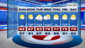
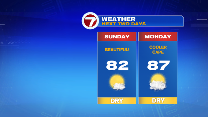
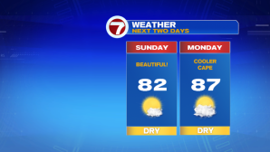
High temperatures this afternoon will reach around 80°, under mainly sun-filled skies, and low humidity – picture perfect for any of those outdoor plans.
Fenway will feel fabulous by first pitch with temperatures in the upper 70s, and winds out of the west – northwest around 10 MPH.

Heading to the beach? Highs will be in the upper 70s, and the ocean water temperature will be in the upper 60s, while the rip current risk is low, the UV index is HIGH so be sure to reapply the sunscreen.

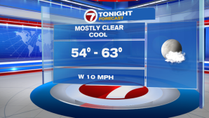
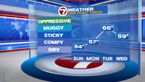
Tonight, temperatures will be on the cooler side, but not quite as chilly as this morning. Overnight lows will slip back into the mid 50s to low 60s under mainly clear skies.
Monday it will still be comfortable, but it will be warmer, with highs in the mid to upper 80s, just slightly cooler at the Cape due to a shift in the wind direction to out of the southwest.
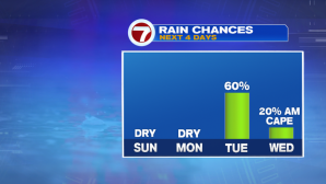
Tuesday is the next best chance for showers and thunderstorms. An isolated shower is possible into southern NH Tuesday morning, otherwise as an approaching cold front sinks in from the northwest, the showers and storms hold off until the afternoon and early evening commute. Keeping an eye on the timing as well as the chance for embedded downpours.
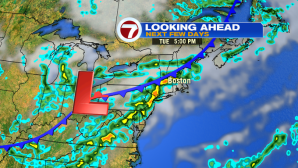
The front moves out by early Wednesday, but a lingering shower for the outer Cape and the Islands is possible before drier and cooler conditions move in.
For the second half of the work week, high temperatures will be in the mid to upper 70s! Next Friday and Saturday looks nice too as we soak up the last few weekends of summer.