Soaking rain is back in the forecast today as steady rain this morning extends through lunch time. At times, the rain will be heavy, creating plenty of slow downs for the morning commute as well as big puddles on the road. Rain does taper off after 2pm, drying out for the evening commute, however, still expect wet roads for the ride home from work as it’ll time some time for the dampness and puddles to dry out.


After another 1-2″ of rain with this storm, many rivers and streams will be near bankfull, and some even going into minor flood stage. The Sudbury River is one of those rivers that will experience minor flooding today and tomorrow.

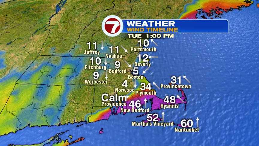
While winds aren’t too much of a concern to most of us today, they will be a concern for the Cape and Islands. That’s where strong gusts, in excess of 50mph, are possible. It’ll also be mild there, near 60.

Cold air starts pouring in here tonight, and the temps barely move much tomorrow as highs hover in the low to mid 30s. Winds gust 30-40mph, while wind chills hold in the upper teens to mid 20s. Brrrr!

There’s certainly no lack of cold air to the northwest of us, and that cold air will help set the stage for some wintry weather in here Thursday night and Friday AM. Away from the coast, many towns and cities will experience their first snow of the season before sleet and a cold rain mixes in and takes over. While it’s too early to throw out snow #s… the best shot for at least a few inches would favor the higher terrain of Worcester County, points north and west. Accumulations across eastern Mass would likely be on the minor side, before flipping to a cold rain.


Stay tuned!
@clamberton7 – twitter