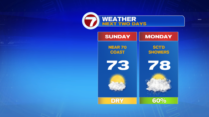
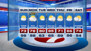
After a chilly start to your Sunday, temperatures will rebound only into the low to mid 70s inland, slightly cooler at the coast (around 70) due to the onshore breeze. Otherwise, we are tracking a few more clouds filling in through the afternoon.

Now for Labor Day, we start off partly cloudy in the morning with temperatures into the upper 50s to low 60s. By the afternoon, temperatures jump into the mid to upper 70s, as cloud cover thickens.
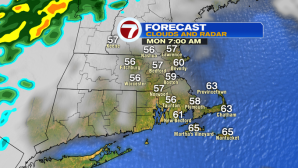
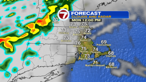
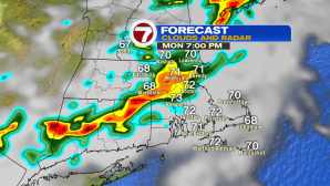
Scattered showers are expected into the early afternoon, with a few embedded downpours and rumbles of thunder likely between 3PM and 8PM. The Cape and the Islands will likely remain dry for your outdoor Labor Day plans.
Tuesday and Wednesday bring back the summery warmth as well as the sunshine with highs into the low to mid 80s. A few thunderstorms are possible by Wednesday evening.
Thursday and Friday trend cooler, back into the low 70s Thursday, mid to upper 60s Friday.
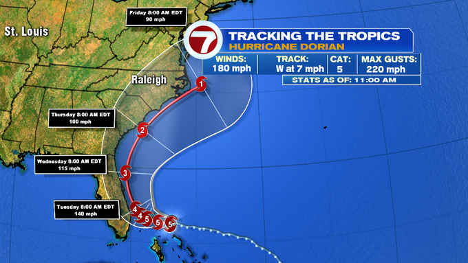
As for Hurricane Dorian, as of the latest update at 11AM from the National Hurricane Center. The storm continued to intensify as it approached the Abaco Islands in northern Bahamas earlier this morning. It is currently a catastrophic Cat. 5 storm, with winds sustained at 180, with gusts over 200 mph. The forecast keeps it at a Cat. 5 status as it hovers over the Bahamas through Monday evening. Life-threatening storm surge, heavy rainfall, and damaging winds will continue to hammer the Bahamas over the course of the next 24-48 hours.
The East Coast of Florida is still included in the forecast cone. If Dorian does not make landfall in Florida, the impacts of Dorian will still be felt due to it’s close proximity to the coast, from storm surge to damaging wind gusts as hurricane force winds extend 30 miles from the center of the storm, with tropical storm force winds over 105 miles from the center.
The forecast cone keeps Dorian as a major hurricane (Cat. 3 or higher) through Wednesday morning. By midweek, the Georgia coast and those in South and North Carolina are in the forecast cone, as Dorian still maintains hurricane status. By Friday, it should weaken to a Cat. 1 near the Carolinas.
As far as the impact here locally in New England, we may see rough surf and rip currents as Dorian passes to our south next weekend. Some clouds and even a few showers are possible early next weekend as the outer reaches of Dorian try to reach the S. Coast and the Cape/Islands.