After Thursday’s wet and humid weather, we are in for a dry pattern over the next several days.
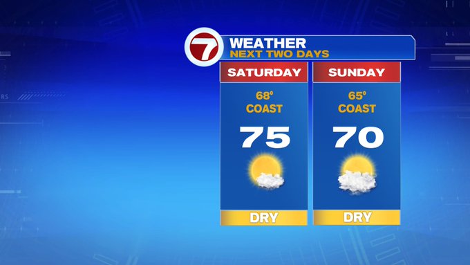
This weekend features nearly seasonable highs, low humidity and an onshore afternoon breeze that will limit temperatures along the coast.
Today is a gorgeous day for any of your outdoor plans (just don’t forget the sunscreen, that UV index is at a 9 this afternoon).

Highs both days likely in the 70s inland, 60s at the coast.


Tonight, overnight lows slip into the mid to upper 40s northwest, low to mid 50s south and east.

The pattern is dry over the next several days because of a high pressure that blocks any system from moving into southern New England. This high also controls the wind direction, which will vary into the middle of the next work week.
Monday, the high is to our north, meaning the wind direction is coming in off the cooler ocean water, keeping temperatures cooler along the coast.

Tuesday afternoon is when we notice the shift to out of the southeast, where temperatures will then be cooler for the South Coast and the Cape and Islands, warmer inland.

Also to note with the dry pattern, followed by the heat and humidity building in the latter half of the work week, don’t forget to water the plants and your lawn since last month and this month so far are below average for monthly precipitation.


The heat we’re talking about peaks next Thursday and Friday with highs into the upper 80s. Friday features a slight chance for a few showers mainly south and east, otherwise we are dry over the next 7 days.
