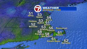
It was a cool, fall-like start to our Sunday with lows starting off in the low to mid 50s for most locations, besides Boston where it started off in the low 60s.
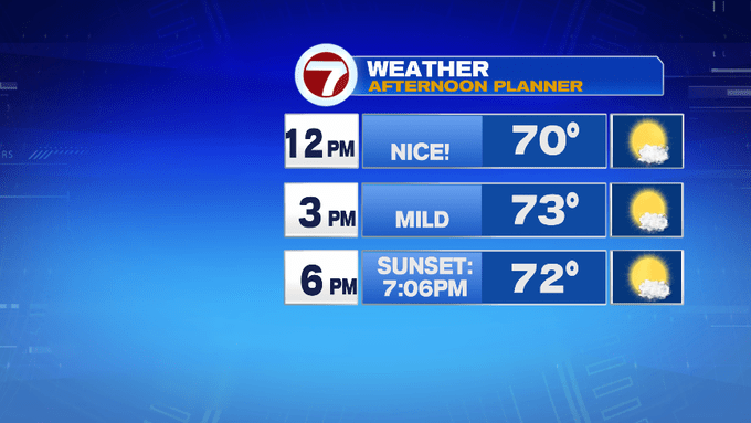
High pressure keeps us quiet and seasonable under mainly sun-filled skies. Highs are expected to climb into the low to mid 70s with a westerly breeze that keeps the seabreeze at bay.

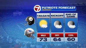
Sunglasses and SPF will be needed for any of your outdoor plans, whether you’re headed to the beach (just be mindful of the high rip current risk today), or if you’re headed to Foxboro to tailgate ahead of tonight’s season home opener.

Tonight, temperatures take a nose-dive after sunset. Sunset now at 7:06PM, with the last sunset after 7PM of 2019 quickly approaching (Sept. 11th), we’ll have to wait until March 23rd, 2020 to see the sun-setting after 7PM.
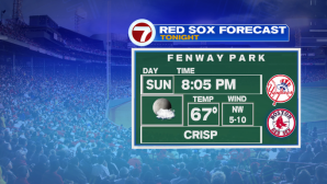
With the sun-setting ahead of both the Pats game and the Redsox game, temperatures will slip back into the low 60s through the games.
Overnight, temperatures will be similar to this morning, but a few spots could slip into the upper 40s, so the kids at the bus stop may need the jacket before heading off to school early Monday morning.
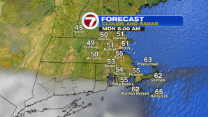
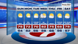
Monday will feature a seabreeze, so temperatures will be back into the 60s at the coast, around 70 inland.
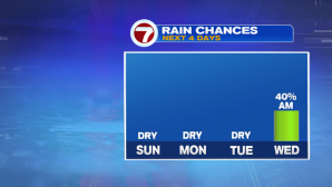
Tuesday will see similar conditions as Monday, but by Wednesday, we see the return of the humidity, showers, and 80° highs. The showers will be mainly confined to the morning hours.
The rest of the week includes rollercoaster temperatures, 70s Thursday, upper 60s Friday, back to near 80 Saturday…but at least we are tracking a warm-up for the start of next weekend!