Here we go! Our first significant snow of the winter is on the way! If you came here for today’s forecast, we’ll cover that first. It’s short and sweet and honestly not much to say. Temperatures won’t move much. We’re waking up in the 30s and we’ll hang out near 40° all day long. This morning watch for black ice as the rain is refreezing in spots with temperatures near freezing. Sun will be out in full force with an occasional breeze. It’s a nice day for January standards.

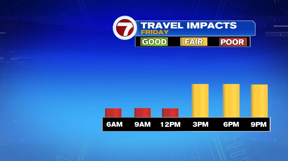
Ok, so now the elephant in the room… Friday! Are you excited?! The snow is exciting for many and definitely will be pretty but the timing is not good. It will be right during the commute Friday morning. Tomorrow is a work from home day if you have that opportunity.
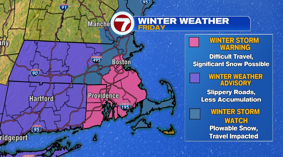
Warnings and advisories have been issued for the area. As of 6am, this is what we have and this is what they mean:
- WINTER STORM WARNING (PINK): Here is where we expect the highest snow totals and the most significant impacts. Travel will be very difficult for your Friday morning commute. It includes everyone inside of 128, 95 corridor to Providence and south.
- WINTER WEATHER ADVISORY (PURPLE): In the winter weather advisory we are still expecting accumulations, but numbers will be less. Travel will be doable here but it’ll still slow and slick so take it easy if you must travel. You’ll notice it lines up with the lower numbers on our snow map.
- WINTER STORM WATCH (BLUE): It’s hard to tell the difference, but you’ll notice blue shading between the warning and advisory. This is a winter storm watch. This is a buffer zone if you will. Later this afternoon, those areas will either be included with the winter weather advisory or upgraded to the winter storm warning. We’ll give the models one more run, fine tune numbers, and try to best determine what sort of travel impacts are most likely and decide from there.
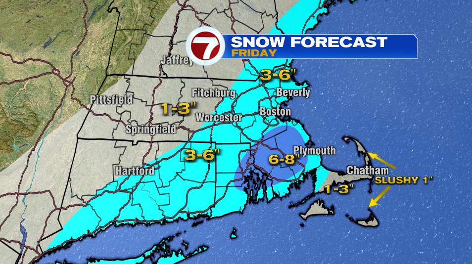
The winter storm warning is where we not only expect the highest numbers but also where we expect the snow to come down the hardest (thus, why numbers will be higher). A wide swath of 3-6″ is expected across the area. Here’s a general rule of thumb for trying to determine what you’ll get.
- Southeast Massachusetts is pretty self explanatory. Most of us there will see at least 6″ of snow. Numbers will be just a hair less along the coastline.
- In and around Metro Boston and everyone inside of 128 is in the 3-6″ band. If you compare the snow map with the warning above it’ll probably shake out something like: 3-6″ band but also in the winter storm warning (pink) lean heavy on higher end of numbers. We’ll likely see a lot of 5″ and 6″ reports inside of 128. In fact, it may need to be watched that we even see a few isolated numbers over 6″.
- For Worcester, Metro West, the Merrimack Valley, and Southern New Hampshire . You’re in the 3-6″ range but that 6″ number is entirely possible. The only difference is confidence is a bit lower. While 6″ is possible, it’s likely that’ll be on the high end of things and there will be a lot of 3″, 4″, and even 5″ reports.
- North of Worcester on the 190 Corridor and West where the winter weather advisory is in effect, expect about 1-3″ of accumulation.
- It’s a bit of a wild card for Cape Cod and the Islands. The question is how much mixing happens here and how much that’ll cut down on numbers. Mixing is most likely on the Outer Cape and Nantucket, so we’ll roll with a slushy inch there. When you get close to the Canal, numbers will come up in a hurry. As you can see, that heavy pocket of snow is not that far away. A slight shift in the track of the storm could keep this all snow and numbers would come up significantly.
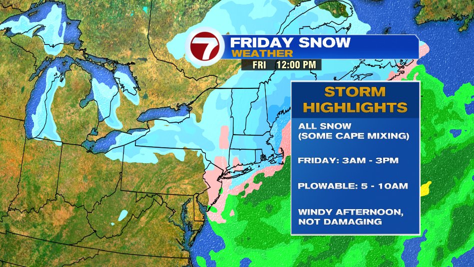
Here’s a few storm highlights, the quick and dirty details:
- Aside from the Cape and Islands, it is all snow all the way through.
- It’s a quick moving storm with snow around for about 12 hours. Starting at 3am and even the flurries are gone by 3pm.
- That said, we’ll get most of the accumulation and plowable snow in a 5 hour window tomorrow morning from 5am-10am. It’ll come down heavy at times — some snowfall rates could be 1″ per hour. It’s very hard to keep roads clear in that heavy of snow.
- Winds are not a concern with this one. It will get a little gusty from the northwest when the snow starts to wind down, but it’s not damaging winds, just your average New England gusty winds.
Travel tomorrow morning is by far the biggest impact and roads are not going to be in good shape. Both from the snow standpoint, but also I expect those that do need to travel or decide to travel will just have commute times skyrocket. It’ll be a great work from home day if you have that capability. Roads will improve in the afternoon but it’ll take time to get roads back to normal.