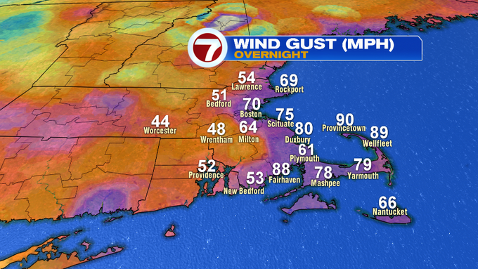
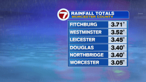
The powerful coastal storm that brought drenching rain and tropical storm force winds (sustained at 39mph or higher) has since lifted north, but is still bringing blustery conditions across southern New England. A few gusts on the Outer Cape reached between 80 to 90 mph!

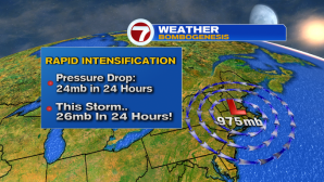
Why was this such a strong storm? The low pressure continued to drop over the last 24 hours, so much so, that it is considered a “Bomb Cyclone” – the name given to a storm that drops 24 millibars within 24 hours…in this case, our storm dropped 26 millibars in 24 hours. It is also known as “bombogenesis”.
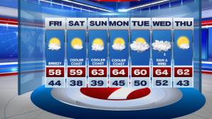
A few showers possible into this evening, but we’ll see a gradual clearing of the skies through the overnight tonight. Breezy conditions are expected to stick around overnight and into Friday, but at least we are tracking the return of mostly sunny skies for the last day of the work week.
For the Head of the Charles this weekend, we’re looking at seasonable conditions, with a light breeze on Saturday and a few more clouds on Sunday.

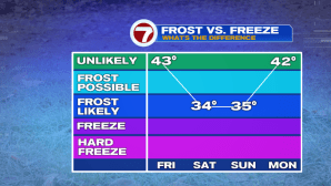
Also for this weekend, there may be some frost early on Saturday morning as well as Sunday morning, especially farther inland, but temperatures will rebound quickly by late morning for any of your outdoor plans.
We’re keeping an eye on a system for late Tuesday into Wednesday that could bring some more rain and wind. Otherwise, temperatures look to remain relatively seasonable through the end of the 7-day forecast.