
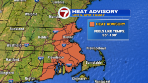
Yesterday’s high temperature observed at Boston Logan was 96°…today will be a tad lower than that, but it will still be dangerous heat for the 4th day in a row. A Heat Advisory is an effect from noon to 6PM since heat index values could reach into the upper 90s to triple digits.
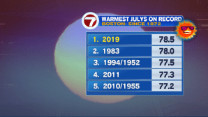
With two separate heat waves this month, it’s no wonder that July 2019 is the hottest on record as of yesterday:
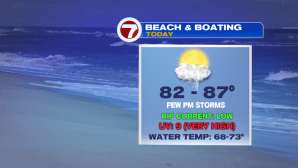
If you’re trying to beat the heat today, the local beaches and pools will likely be the place to be, that is, until the scattered thunderstorms stroll through.
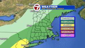
Some of these storms could be on the stronger side, with gusty winds, embedded heavy downpours and frequent lightning being the main impacts. The Storm Prediction Center (SPC) has placed southern New England under a marginal risk for strong to severe storms. There’s a higher risk to our southwest – for NYC, Philadelphia and NJ.
As for the timing of these storms, your lunch time should be dry, but the early afternoon/evening commute will be quite active. Between 4PM and 7PM, the storms start to flourish with embedded downpours and a few of the storms producing gusty winds. These will sweep out by sunset, a few spotty showers lingering overnight.


We see relief from the heat tomorrow, but the humidity sticks around. Friday features low humidity and highs into the low 80s under partly cloudy skies making for a beautiful and seasonable end to the work week.