Wednesday brought increasing cloud cover through the day with highs around 80 inland, 70s for most, with an onshore breeze that cooled things off for Boston mid-afternoon (cooling into the mid-60s by 2pm).
Your forecast this evening features a spot shower chance (check the 7Weather app before your evening run/walk).

Overnight, temperatures do not cool off all too much with lows into the 50s and 60s.

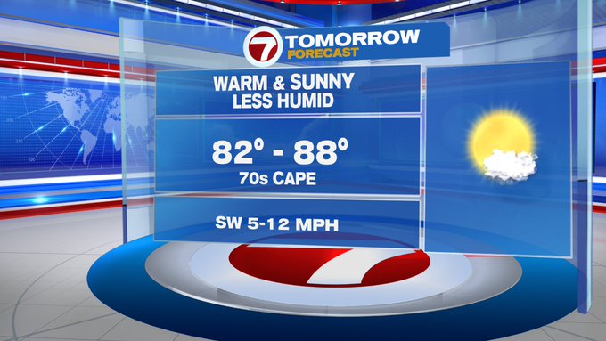
Thursday is the pick of the week with highs stretching into the 80s for most places (away from the Cape and Islands where highs will be in the 70s). We’re tracking the summery warmth, but without the humidity under mostly sunny skies! Great weather for any of your outdoor plans.


Rain chances return Friday and into the weekend. We’re not tracking washouts for your weekend plans, just a few showers Friday, scattered Saturday, back to a few showers Sunday. Overall, the best chance for showers will be Saturday, plus a few rumbles of thunder cannot be ruled out.

As a reminder, since we are now in meteorological summer (June 1st – August 30th), when you hear thunder and you’re outside, you are close enough to be struck by lightning. So, when thunder roars, go indoors.
As previously mentioned, we’re not tracking washouts through this weekend, so we’re looking at much relief for allergy sufferers as the pollen count will remain in the high category through Sunday.

The humidity returns with the warmth into Friday and Saturday, turning cooler and less humid into the next work week.

Quick tropical update: We’re already on our third named storm of the Atlantic hurricane season, Cristobal. As of the 5PM update, Cristobal is at Tropical Storm-strength and continuing to bring flooding rain to portions of eastern Mexico. Cristobal is expected to weaken over the next 24 hours over land, then make a turn to the north over the warm waters of the Gulf of Mexico and strengthen Friday and Saturday.
