Hello there! It’s been a while….hope you are well these days!

After last night’s intense squall line, we were back to more typical fall weather today. Still some leftover wind through the day tho with wind gusts still between 20-30 mph. Thankfully, that wind fades away overnight and won’t pester you on Friday either. Of course, taking the wind away allows for the crisp autumn day to give way to a cold night. Most towns by early Friday morning will see temps briefly dip into the low 30s! Map shows temps around 7am Friday morning…
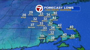
Away from the coast, that should be cold enough for frost. If you still have a traditional commute with a car, plan on scraping some frost off the windshield…if by some chance you are still into the gardening scene, protect those plants!….Mums and pumpkins should be fine (not cold enough to be concerned about damage to them).
Some absolutely fantastic fall weather on tap for tomorrow. Sunny skies, crisp air and a break from the recent windy days. Afternoon temps around 60! The next several days are dry as the drought continues to be relentless. Check out the 7-day forecast…
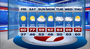
Dry. There IS a chance of some rain toward the middle of next week and that has the potential to be more than just a few showers. That rain could be leftover moisture from what is now Hurricane Delta (making landfall tomorrow evening in Louisiana). We don’t have to worry about storm surge or destructive winds, rather just the good stuff. Rain. The setup we’ll be watching will be a cold front racing across the nation next Tuesday-Wednesday. Depending on how the front interacts with the moisture will determine just hot much rain arrives but at least it’s a shot!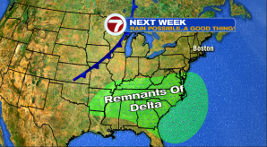

We shall see….regardless….enjoy the fabulous day tomorrow (Friday)
~JR