Today was certainly the pick of the week with highs around 70, less wind and mainly sunfilled skies. Tomorrow brings back the humidity and some strong thunderstorms developing by late afternoon and continuing into the evening.
This evening, we’ll see increasing clouds ahead of our next system that will bring two waves of rain with the second round bringing the strong to possible severe thunderstorms for southern New England.

Tonight, we’ll see a few scattered showers late, otherwise we’re looking at mostly cloudy skies and mild temperatures. Overnight lows only slip into the upper 40s to low 50s with a calm wind.

Friday, we start off with scattered rain showers, with a few pockets of heavy downpours, especially along and south of the Pike. These move out and we’ll see some glimpses of the sun by late morning.


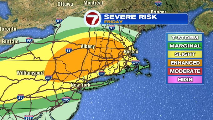
Depending on how much sun we see tomorrow afternoon will be the deciding factor on how strong the thunderstorms will be. The more sunshine, the greater the threat for stronger storms. The Storm Prediction Center has put areas west of the 495-corridor under an enhanced risk for severe storms (3 out of 5 on severe thunderstorm scale).

Now, let’s get to the timing. We see some dry times between 9AM and 3PM.

By 4PM, a few storms start bubbling up to our west, just ahead of the cold front. This front is budding up with the warm, moist air, creating the battle zone for the thunderstorms to thrive off of. This thunderstorms start to become more numerous and start advancing from west to east across southern New England. Some of these storms could bring gusty winds with some hail possible. Some minor localized flooding cannot be ruled out.


Expect the thunderstorms to be in Worcester County between 5-6PM, and into the 495-corridor between 6-7PM, Boston and the coast from 7PM – 9PM. These storms are expected to linger through 11PM.
Just how warm will we get on Friday? We’re looking at highs into the low to mid 70s.

Will this warmth stick around for the weekend? The answer is yes, but thankfully it looks like the humidity clears out as the cold front moves out late Friday night into early Saturday.

The weekend features highs around 70 Saturday, slightly cooler at the coast due to an onshore breeze that develops into the afternoon. Sunday brings seasonable temperatures with highs into the upper 60s. Overall, both weekend days feature a mix of sun and clouds and mainly dry conditions until Sunday night when our next chance for rain moves in.

The set-up for the start of the next work week features a system moving in from the midwest that meets up with an ocean storm, bringing a wet, windy and cooler start to the week. Most of Monday looks wet and windy, while Tuesday we finally catch a break by the afternoon as the rain moves out.

Drier by midweek followed by a warm-up Thursday with highs into the upper 70s!
