
After such a gorgeous weekend, it’s time we turn the page to the work week.
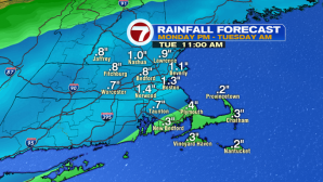
The warm-up we saw for our Sunday will trickle into the start of the work week. As a cold front approaches from our west, it will usher in breezy conditions out of the south-southwest, as well as some rain showers.


We start off dry for Monday morning’s commute, but the clouds will be prevalent. A chance for an inland shower ahead of the main line of rain by mid-afternoon, otherwise the rain fills in by at least 7PM across the region. A few showers will be heavy at times Monday night into early Tuesday morning before moving out to sea.


Drier conditions move in by Tuesday afternoon, as well as a glimpse of sunshine from west to east as clouds move out, too. Highs are much more seasonable- back into the mid 60s.

The end of the week features some uncertainty as a coastal system may bring some gusty NE winds and a few showers for Friday and into next weekend. We will continue to keep an eye on that as we get closer.
