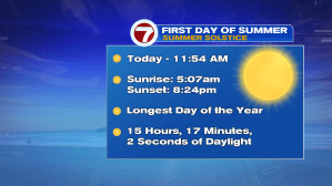
It wouldn’t be the end of the THIS work week without mostly cloudy skies and a few showers. We’ll continue to see the showers/clouds linger through at least 7PM at the coast, 8PM for the Cape and Islands.
The good news is that the sunset this evening is not until 8:24PM, due to the Summer Solstice – the longest day (in terms of daylight) of the year for the northern hemisphere.
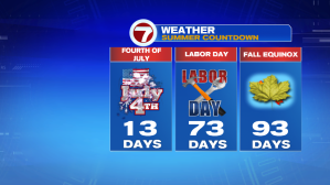
And since we are no longer counting the days (hours, minutes, seconds…) to the first day of summer, we’re less than 2 weeks away from Independence Day, a little over 70 days until Labor Day, and just 93 days until Fall (for the foliage lovers of New England, I had to include that in the countdown).
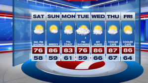
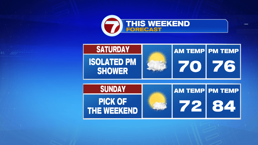
Now back to the forecast. If you’re heading out to Fenway this evening, there might be some drizzle ahead of first pitch, but the gradual clearing of the skies will continue through tonight. Tomorrow’s afternoon game will feature breezy conditions with temperatures into the mid-70s. Sunday brings on the heat, with temperatures into the low 80s under mainly sunny skies (do not forget the SPF…the UV Index is up to a 9 on Sunday afternoon, meaning you could get sunburn in less than 20 minutes if you are not properly prepared).

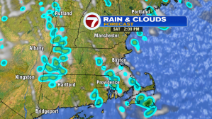
We have a disturbance that passes through Saturday afternoon (between 2PM – 6PM), that could spark up a pop-up shower. These will be quick-movers, and very isolated, meaning most places will see more dry times than wet.

This is why we’ve picked Sunday as the “pick of the weekend” due to the mostly sunny skies and highs into the mid-80s!

The 80s stick around for the start of the work week (away from the coast…a seabreeze develops at the coast Monday afternoon keeping temps in the 70s). Tuesday features more clouds and a chance for afternoon/evening showers, with a rumble of thunder possible. Highs dip into the mid 70s Tuesday before rebounding back into the mid to upper 80s from Wednesday – Friday…along with the humidity.