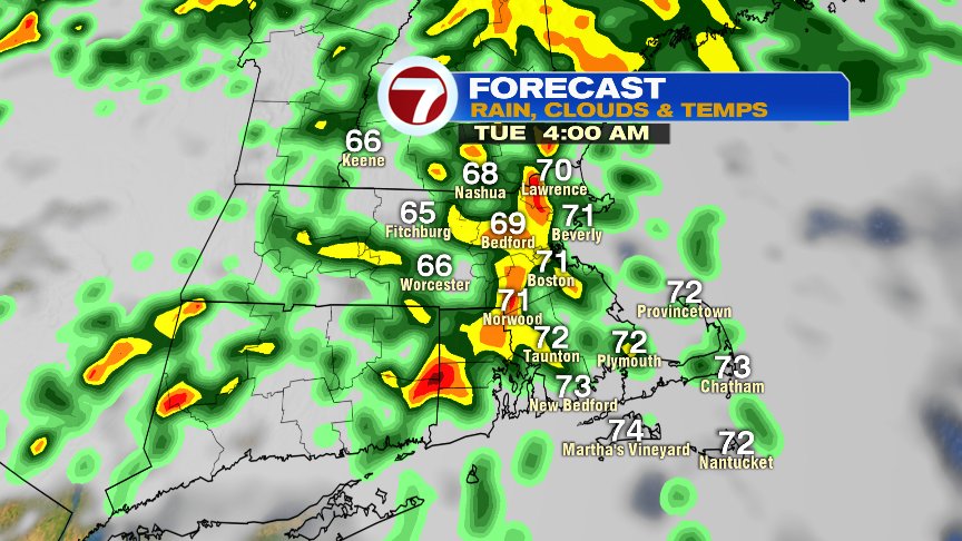
Picking up right where we left off over the weekend, and that means cool air prevails with below seasonable temps for today. Not only do we have cool air in place, we’ll also have some wet weather move in by this afternoon. Most of the rain is light, but enough to keep it damp and chilly later today into the evening.

Overnight tonight, a warm front lifts on through, providing more showers and even some embedded thunderstorms overnight. With any thunderstorm, localized downpours are possible. Temps warm from the upper 50s this evening into the upper 60s to near 70 by daybreak tomorrow.
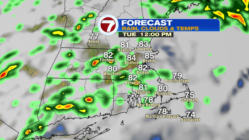
Tomorrow will be warm and humid with hit or miss showers/storms around thanks to some instability and a summery soupy air mass in place. Highs reach the low 80s and dew points spike back into the low 70s.
Update on Florence…
This morning, Hurricane Florence is a category 2 storm, and one that will continue to strengthen over the next couple of days. It’s highly likely that Florence reaches at least category 4 status in the coming days and all eyes in the mid-Atlantic and Carolinas will be watching it’s track. As it approaches the U.S. Coast, there will be multiple hazards to watch for.. Not only will Florence pack damaging winds and storm surge at/near point of landfall (Thursday night), it’ll also provide the potential of a ton of flooding rain.

Typically, storms that near the Southeast U.S. can move north at a fairly quick pace, but with a blocking high anchored over New England, Florence likely slows/stalls/loops down in the Southeast, providing prolonged flooding rains there. Virginia and North Carolina right now look most primed for the heaviest rains. How far inland those heavy rains go, will be dictated by the track of Florence. The closer Florence stays to the coast, the less widespread the flooding rains are. The farther inland Florence goes, the more widespread the flooding rains will be.

For us in New England, the main influence in our forecast this week appears to be rough surf and high risk of rip currents along south facing beaches, especially the south coasts of RI and the Islands. As high pressure remains in place through the weekend, Friday-Weekend looks dry here. If any tropical moisture gets in here, it would most likely hold off until early to mid next week. We’ll keep an eye on it and update you as Florence pushes forward over the coming days.
@clamberton7 -twitter