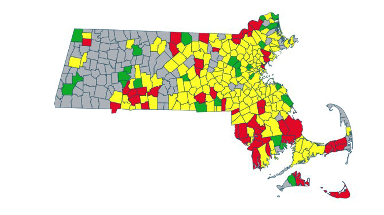
BOSTON (WHDH) - The Massachusetts Department of Public Health released an updated map on Thursday showing the number of cities and towns that are “in the red” and considered high-risk for coronavirus transmission.
Forty-eight cities and towns now fall in the Department of Public Health’s highest-risk category for COVID-19 transmission under the state’s guidelines, down from the 59 that were reported last week.
The high-risk communities include:
- Lowell
- Dracut
- Methuen
- Lawrence
- Haverhill
- Peabody
- Lynn
- Revere
- Adams
- Southwick
- Holyoke
- Chicopee
- Ludlow
- Palmer
- Hampden
- Springfield
- Winchendon
- Templeton
- Townsend
- Ayer
- Sterling
- West Boylston
- Sutton
- Upton
- Bellingham
- Plainville
- Seekonk
- Rehoboth
- Swansea
- Taunton
- Berkley
- Freetown
- Fall River
- New Bedford
- Westport
- Brockton
- West Bridgewater
- Carver
- Plymouth
- Wareham
- Brewster
- Harwich
- Dennis
- Yarmouth
- Nantucket
- Edgartown
- Oak Bluffs
- Tisbury
Click here to view a full town-by-town breakdown of data for all 351 communities in the Commonwealth.
Click here for more coronavirus coverage.
(Copyright (c) 2024 Sunbeam Television. All Rights Reserved. This material may not be published, broadcast, rewritten, or redistributed.)