
Last weekend when we saw highs into the 70s both weekend days was a nice, spring tease, but winter makes it’s swift return this weekend. Incredible the difference a week makes.

This morning, bitter cold temperatures greeted us, and temperatures will not recover much into this afternoon. Expect highs today into the mid to upper 20s. As far as timing of the leading edge of snow, by dinner time, the flakes start to fall.

Tonight, temperatures rise from south to north, which will bring some wintry mix and eventually just rain showers around midnight as the rain/snow line lifts northward.


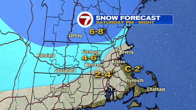
Overall, we’re looking at 4-6″ of snowfall in the areas under the Winter Storm Warning, the Merrimack Valley, and northern Worcester County, Middlesex County. 2-4″ of snowfall within the 495-corridor, and along the coast from the North Shore to Boston, to the South Shore.
Sunday, we dry things out, and we’ll see the return to sunshine with highs into the upper 30s to low 40s, with a gusty breezy out of the west – northwest.


By Monday, temperatures turn colder with highs into the 20s, back into the 40s by the end of the week.
