The big storm that brought whipping winds and heavy rain has finally released New England out of its’ grips. It was a breezy Friday afternoon, but the wind will continue to fade into this evening and through the overnight, as well as a gradual clearing of the skies.
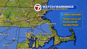
As high pressure slides into New England, temperatures overnight will take a nose dive. A Frost Advisory has been issued for portions of SE MA (away from the coastline). Areas of patchy frost are expected early Saturday morning, away from the coast.

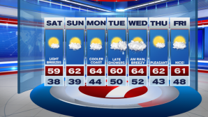
After a chilly start, temperatures will rebound by late morning and continuing into the afternoon under ample amounts of sunshine- great for any of your outdoor plans.

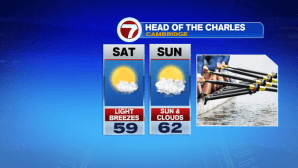
It is looking nice for the Head of the Charles Regatta – both for competitors as well as spectators!
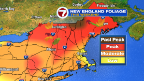
Also, for any of your fall festivities – from apple picking to leaf peeping…both weekend days look great!

A quick check of the tropics, as another storm has been named.
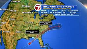
That is Nestor, a tropical storm in the Gulf of Mexico, which is expected to make landfall along the Florida Panhandle later tonight, and continue to weaken in the southeast of the United States before climbing off coastal North Carolina and Virginia, late Sunday into Monday.
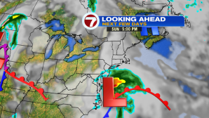
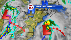
As high pressure blocks the remnants of Nestor from moving north and out to sea, the storm churns before meeting up with a front on Tuesday/Wednesday, which will bring a few extra showers to southern New England by midweek. It will be breezy, but not nearly as windy as our last storm. Again, the timing is late Tuesday into Wednesday for our next round of showers.
Overall, the 7-day forecast looks to remain relatively seasonable in terms of temperatures.