
Good morning and happy Friday! We have quite the stretch of events ahead, so let’s get planning.
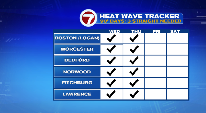
Starting with today, you may not be surprised to hear that the heat wave is still hanging on.
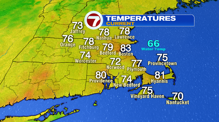
We’re starting the day with temperatures in the 70s and low 80s (right around where our HIGH temperatures should be for this time of year), feeling like the mid 80s with the humidity.
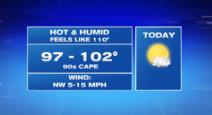
By this afternoon, highs jump into the 90s, and a few spots could hit the triple digits. The biggest issue is that between the high temps and humidity, it will feel like it’s up to 110 degrees in the afternoon. Be mindful of the heat! You’ll want to make sure to hydrate (start drinking water before you get thirsty), and take breaks in the A/C if you have to/plan to spend any time outdoors.
We also have the potential to see an isolated thunderstorm later in the afternoon/evening. Most people will spend the day entirely dry, but don’t be shocked if you see some rain or hear a rumble of thunder, particularly in Central and Western Massachusetts.
Tomorrow will still be hot for the 4th of July– that’s my big focus item for you as we head into the holiday weekend. While temperatures won’t be as hot as yesterday and today, it’ll still be dramatically above average with highs in the 80s for most of the coast, and 90s for just about everybody inland, especially along the 495 corridor.
It’ll still be humid as well, so temperatures will feel like they’re in the triple digits during peak heating.
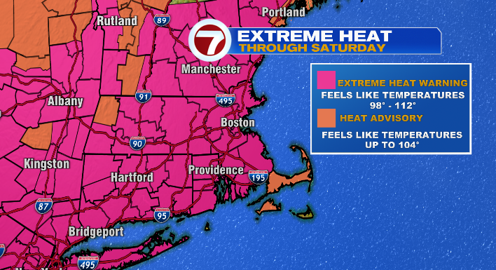
With all of this, our Extreme Heat Warning will continue until 8 PM on Saturday, as will our Heat Advisory.
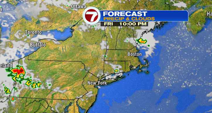
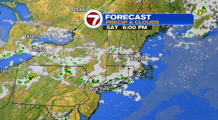
Aside from the heat, the other important note for the 4th is that the front that will finally help to break the heat could also help spark an isolated thunderstorm or two during the second half of the day. While the highest chance for a punchy storm is farther to our southwest, we may see one or two sneak into Massachusetts between noon and 8 PM as a cold front moves through the region. In a similar fashion to today, most people will stay totally dry on Independence Day, but don’t be caught off guard if you need to duck inside for a passing storm.
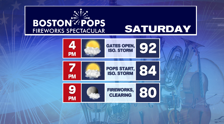
When it comes to the Boston Pops Fireworks Spectacular, things are looking great for the most part! Just a reminder that event organizers have pushed back the gate-opening until 4 PM to keep people from hunkering down in the heat. It’ll still be quite warm when the show kicks off at 7 PM (expect the mid to low 80s), but more manageable than highs in the middle of the day. We’ll be keeping an eye out for a passing storm in the vicinity of the Esplanade as gates open, but that chance is gone by the time fireworks begin at 9:15.
The second half of the weekend will have a much different feel! Don’t get me wrong, it’ll still be above average, but temperatures and humidity will come down significantly. Highs will be in the 80s with dew point temperatures dipping back into the 50s. Overall, it’s a really solid end of the weekend for a more comfortable, summerlike feel.
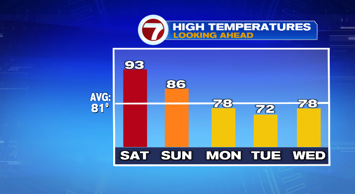
We’ll cool down even more for the start of the coming week– Monday will be in the mid 70s while Tuesday will be in the low 70s. Our next system also rolls around Monday afternoon/evening, bringing showers and some rain. Scattered showers continue on Tuesday.