After a gorgeous start to the weekend and a brief break from the humidity, the second half of the weekend is bringing higher dewpoints, more cloud cover, and a chance for an isolated thunderstorm later today. Some of these storms could be on the stronger side, but these will be very isolated.


The severe weather threat remains to our west into the Berkshires and portions of CT, while Worcester Co. and SW NH included in a marginal risk of severe weather.

Tonight, clouds to a partial clearing after midnight, plus not much relief as lows only slide back into the low 70s.
Monday is the hottest day out of the next seven days as highs stretch into the low 90s, away from the Cape and Islands, under mostly to partly cloudy skies.

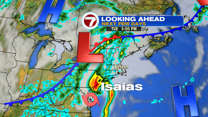
We’re continuing to keep a close eye on the track and intensity of Tropical Storm Isaias that is currently skimming the southeastern coast of Florida.


The forward motion of the storm should gain speed as it climbs up the eastern coastline, slipping into southern New England Tuesday evening. This will bring much needed rainfall (most of our area is under a moderate drought), but the tropical downpours will bring between 2-4″ of rain in a 24 hour period, which could create some minor flooding.

The storm will also bring some gusty winds, with gusts up to 45 mph possible Tuesday night into Wednesday.


The good news about the storm is that it doesn’t linger much after Wednesday morning. Drier conditions are expected later Wednesday, as a cold front sweeps through and clears the area of the humidity, giving us a less humid, mainly sunny, and seasonable end to the week, and that nice weather continues into next weekend.


