
Quite a few locations saw morning lows slip to the freezing mark early Saturday, allowing for some patchy frost to develop.

We’ll likely see similar conditions tonight into early Sunday morning under mainly clear skies and high pressure overhead.
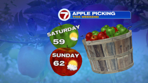
However, we still have to get through the rest of our Saturday forecast before we chat about Saturday night. Today, temperatures will climb into the 50s to low 60s under sun-filled skies and less wind- great for the Head of the Charles Regatta as well as any of your fall outdoor festivities.

Sunday, we start off sun-filled before more clouds start strolling in through the afternoon. A shower chance is possible along the South Coast/Cape and Islands Sunday evening into early Monday morning on the outer fringes of the remnants of Nestor.
Post Tropical Storm Nestor is expected to make landfall later today along the Florida Panhandle, but it has already caused flooding and sparked up numerous tornadoes in Florida late Friday night into early Saturday morning.

Nestor will continue to weaken over the course of the next 24 hours as it tracks north and eastward over Georgia, and the Carolinas before meandering over the mid-Atlantic for a few days.


Tuesday and Wednesday is when we’ll likely see more widespread rain, but this time more so associated with a system that will be traversing the Midwest tomorrow. This system will likely bring more fringe showers from a weak Nestor into Southern New England Tuesday afternoon and continuing into early Wednesday. Expect breezy conditions early Wednesday, but not to the caliber of the winds we felt last week.
Overall, not big changes in temperatures from day to day. We remain relatively seasonable through the end of the next work week.
