While the day was damp and dreary – it wasn’t a complete washout. Most areas picked up barely 0.10″ by 6pm. Temps were climbing through the day, topping out in the low to mid 40s for many. I know my humble opinion doesn’t mean anything, but when there’s no wind 40’s can feel really good this time of year.
We still have a few more hours of wet weather to go before we dry out… and the heaviest of the rain is yet to come. Plan on some soakers, and even a few rumbles of thunder, from about 10pm through 1am… with showers tapering and moving out between 2-3am. All said and done, we’re looking for rainfall totals somewhere between 0.50″-1.00″ for most with maybe a few isolated locations coming in closer to 1.50″+ (most likely SE Mass).
We will be dry by the morning commute, and it doesn’t look like temps will crash overnight. Waking up tomorrow morning, a few clouds will still be around – but temps will still be above freezing. Despite a good deal of sunshine tomorrow, it’s a bit of a “backwards” day. Temps will hold fairly steady and then slowly fall getting into the later afternoon hours. By tomorrow evening, most spots will be in the upper 20s – which is about 20 degrees cooler than this evening was. Also, plan on a gusty breeze out of the NW tomorrow, adding a bit of a bite to the “real feel.”
Tuesday is fairly similar to Monday, although a bit less wind. So, two quiet days are ahead of us to recover from this big Super Bowl Sunday… and then Wednesday comes along.
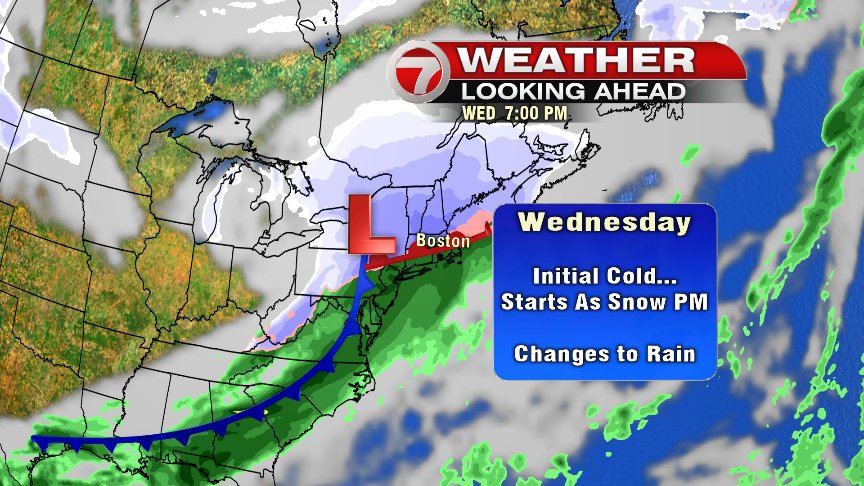
There’s a lot to keep an eye on with this set up for Wednesday, and forecast models have been trending colder with this one. The cold air is in place by the time the precip arrives – and that cold looks like it will hold… which means that precip moving in will most likely be snow. The onset of this snow may hold off until the afternoon and evening hours and continue overnight – which could leave the Wednesday morning commute unaffected.
There is some milder air that wants to move in and push the rain snowline farther north – but there are still a couple of questions here that still need to be answered: How quickly will that happen? How far north are we talking? Regardless, I think it’s likely that north of the Mass Pike we’ll end up with several inches of snow accumulation before a potential changeover to snow (but it may never happen for this area). Plowable snow (a couple to a few inches) looks fairly likely for the rest of us, with the quickest changeover to snow reserved for the Cape and islands, which may only leave behind a coating to an inch or so. It looks more likely than not that we’ll be making up another snow map for Wednesday – but those specific numbers are not nailed down yet. Stay tuned. – Breezy