Editor’s Note: Tonight’s blog is written by 7Weather intern, Owen Vetree ~JR
Good afternoon to everyone on this hot and humid day. Today was the second hottest day of the year so far, emphasis on the so far, as it will likely find its way down to fourth or fifth over the next 3 days.
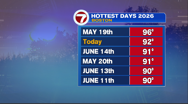
We had a stretch of hot days in June. Back on May 19th we got up to 96 which still holds the number one spot for the year. We can expect that to change tomorrow. July is wasting no time in joining the 90 club this year.
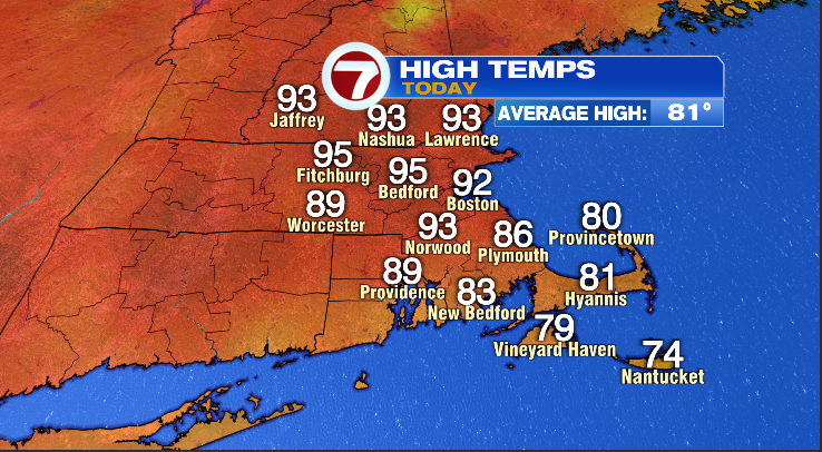
Boston came in at 92 for the day with most spots north and west of the city a couple of degrees higher in the mid 90s. The South coast and the Cape managed to stay in the 80s, while the islands actually held in the 70s. Nineties are hot but not all that unusual; the temperatures tomorrow and Friday will challenge records. For Boston, the records are 98 tomorrow and 102 Friday while Worcester’s records sit at 97 and 96 respectively.
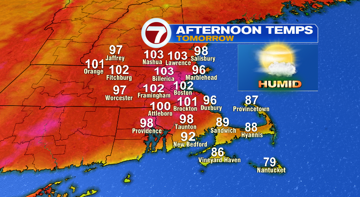
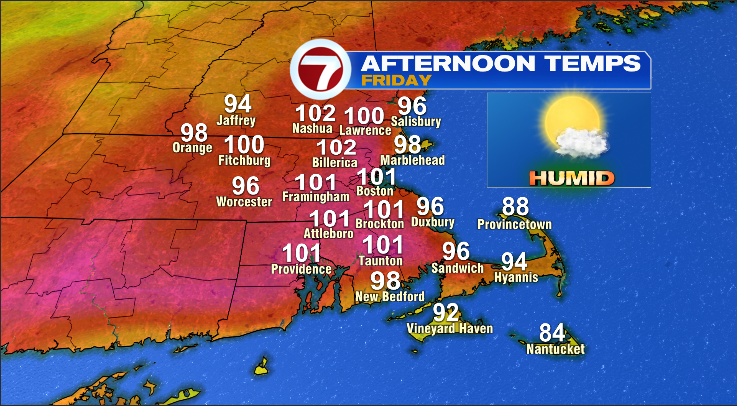
Both days possibly over 100 for most areas with the big exception being the Cape and the islands. However, you’ll notice on Friday even the Cape gets quite toast with highs in the mid 90s for a large portion of the peninsula. Even Marth’s Vineyard gets into the 90s.
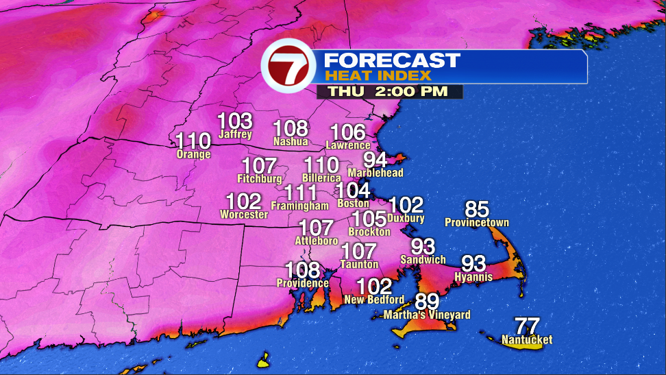
One hundred sounds bad on its own, but once you factor in humidity, the apparent temperature gets even higher. Readings over 110 for a number of spots are possible to likely. The map above is showing the forecasted heat index for tomorrow. You can expect very similar values on Friday with the only big difference being on the Cape where the heat index value will get up to around 100.
If anyone is working outside or planning any holiday activities over the next two days, it is important to take the heat seriously. Do not push yourself and take lots of breaks during your work. Avoid being outside for long periods of time as heat stroke will occur if you are not careful.
Once we make it through Friday, Saturday will start our cooling trend back down towards more normal conditions for our area.
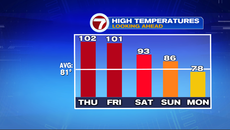
Saturday won’t see complete relief from the heat but to be honest, it might feel decent compared to Thursday and Friday. Sunday will still be warm but the heatwave should officially come to an end. Might be time to break out the sweater again for Monday with highs failing to reach 80.
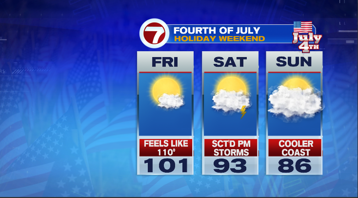
The holiday weekend is looking pretty good for the most part. After the dangerous heat on Friday. The fourth will be hot but manageable with a low risk for a couple of thunderstorms in the afternoon. The best day of the bunch looks to be Sunday the fifth. Temperatures in the 80s will feel great. There is a good chance we see that humidity back off as well.
~Owen