Here are the updated details for Round 4:
- Timeline: The snow is slow to move in through the day tomorrow, and takes until maybe 1pm to move up to the Mass Pike. Even as we move into the afternoon, the snow will be slow to become widespread north of the Pike, and it shouldn’t be falling heavily enough at this time to really accumulate on the roads quickly. Once the sun goes down (around 7pm), that will change. The accumulating snow happens overnight and tapers off Thursday morning.
- Impacts: Plowable snow, wind gusts 45-55mph (especially along the coastline), difficult travel Wed PM, minor/moderate coastal flooding for early Thurs AM high tide (around 3:15am).
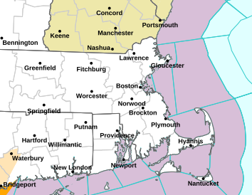
- You’ll find the current snowfall forecast map at the top of this post. This storm is taking a southerly track, so we have shifted the highest band (6-10″) to account for that. You’ll find the snow becomes wetter/heavier as you move S&E where we get more mixing with rain.
- A Winter Storm Warning (pink shaded area) has been posted by the National Weather Service for south of the Mass Pike where the confidence for at least 6″ of snow accumulation is. The Winter Storm Watch (blue shaded area) is still posted north of the Pike to say, “we could see 6″ of snow in this area, but we’re not certain of it… so we’ll WATCH for that signal in later forecast model runs):
- Wind is out of the northeast – which is what makes this another “nor’easter.” Gusts will be between 45-55mph with the strongest wind expected Wednesday evening. A High Wind Warning has been posted for the Cape and islands for gusts up to 60mph possible there. A Wind Advisory is posted for the coastline.
- Coastal Concerns: Astro tides are higher than they were with the last storm… up to 10.12′ for Boston – and add in a 2.5 to 3′ tidal departure on top of that. There could be minor to pockets of moderate coastal flooding, especially along the South Shore, Cape and islands during the early Thurs AM high tide (around 3:15am). A Coastal Flood Watch has been issued:

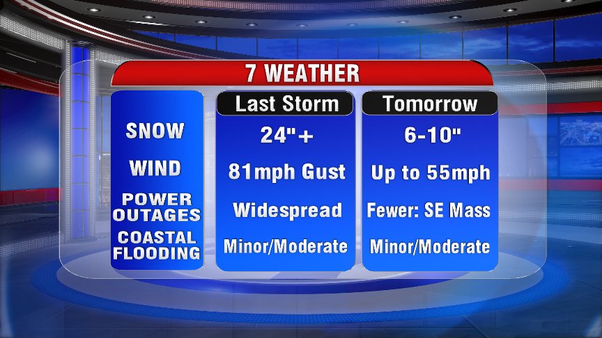
My boss asked me to put together a comparison of this storm vs. the last storm (the blizzard on March 13th)… These will be two very different storms if the forecast pans out. Take a look at the side-by-side:
Glad we don’t have to deal with THAT again!
Hey, one more thing before you go… Spring began today! And Chief Meteorologist Jeremy Reiner is a very talented photographer!
The Force is in balance today…Vernal Equinox about an hour away. #IAmOneWithTheForceTheForceIsWithMe #EggsBalanceAnyDayOfYear #7news pic.twitter.com/ujd98P14Dm
— Jeremy Reiner (@jreineron7) March 20, 2018