What. A. Day. High skies, low humidity and your favorite hockey team has a chance to hoist Lord Stanley’s cup on home ice. Sweetness. The weather is just fine right into late evening thanks to High Pressure close by.
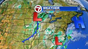
Also what you notice are two red L’s….two areas of low pressure. Thing 1 and Thing 2 if you will
Oh the places they’ll go……to New England tomorrow! Thankfully, they join forces as one storm and move along at a fast pace. Storm Deets:
* Rain arrives 9-10am and is heaviest between 10am-4pm. Both commutes should be spared the steadiest rain.
* Rainfall amounts around 0.5″ for much of metro Boston (lesser amounts west and high amounts across SE MA) this map illustrates that thought..
* There will be some wind along the coastline, timing coincides with rainfall (10am-4pm). Umbrellas have a tough fight ahead of them (especially SE MA)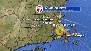
Thankfully, we come out of it by Friday with a mix of clouds and sunshine, breezy conditions and perhaps a few brief showers/sprinkles up in Worcester county/southern New Hampshire. As for the weekend, it is a split with Saturday being the pick of the weekend…mostly sunny, low humidity and mild temps. Sunday is not a washout (like tomorrow is) but the risk is there for a few early day showers and lots of clouds. Still some time to tinker with that Sunday forecast tho…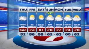
Enjoy the game tonight! Go B’s!
~JR