
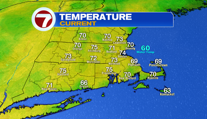
Good morning and happy Friday! We’re starting out very warm today with temperatures in the 60s and 70s, but that’s nothin’ compared to the afternoon.
Once again we’re very toasty with temperatures in the upper 80s and low 90s (though the coast will stay in the 80s). With dew point temperatures in the 60s and 70s, the humidity takes the afternoon feel from hot to downright swampy.

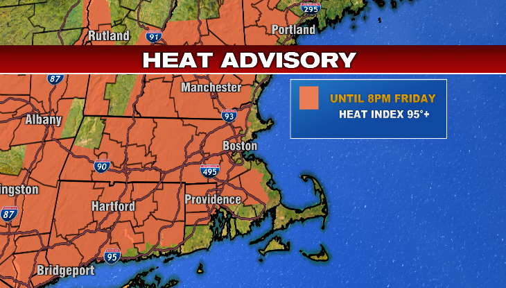
Heat indices will surpass 95 degrees this afternoon, and for that reason, most of the area is in a Heat Advisory until 8 PM. Make sure you’re staying hydrated and taking breaks in the A/C when you can!
That includes if you’re heading out to FIFA Fan Festival in Boston! Today’s the first day of Fan Fest, and while it looks like it’ll be a blast, event-goers will be dealing with the uncomfortable heat in the afternoon.
The other factor in today’s forecast is the potential for a few storms in the afternoon, one or two of which could be a bit punchy with heavy rain, thunder & lightning, and gusty winds possible too. The chance of a storm is higher for central and western Massachusetts, but any activity we see will be spotty overall.
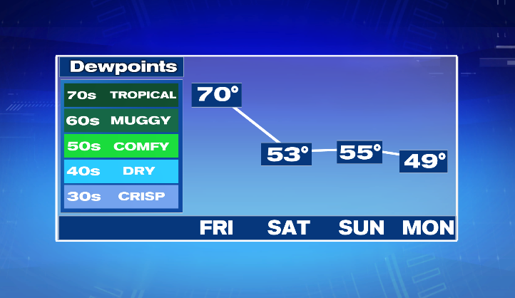
With a cold front coming through later today comes the end of the humidity, and the start of what I think could be the best weekend we’ve had in MONTHS.
Let’s start with this– the biggest factor as we head into the weekend is that humidity will drop significantly.
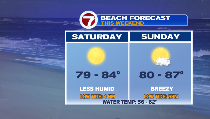
It’ll be a hot but dry feel both days! Saturday will be mostly sunny with highs in the mid 70s to mid 80s for the coast, and the mid 80s to low 90s inland. In my humble opinion, it’ll be a perfect day for the beach or a pool!
It’ll also be a beautiful, warm evening for the first World Cup game at Boston Stadium (aka Gillette)! Haiti will be taking on Scotland with kickoff at 9 PM. Event-goers can expect temperatures in the upper 70s at the start of the match, and mid 70s by the end.

As for Sunday? A few changes, but an overall nice day as well! We stay toasty and dry, with temperatures in the upper 70s to mid 80s for the coast, and mid 80s to low 90s inland. We’ll start mostly sunny, but clouds will increase throughout the day as a cold front closes in. This front will produce some showers, even a storm possible, but timing is on our side! The daylight hours stay dry, and rain doesn’t arrive until after sunset.
After this front, humidity stays low, but temperatures finally drop back toward normal. Monday will become mostly sunny as showers, and eventually clouds get a move on in the morning. Temperatures will be in the low 80s. Tuesday will be ever-so-slightly cooler with highs in the upper 70s and low 80s. We stay mostly to partly sunny, giving us an overall beautiful start to the week!