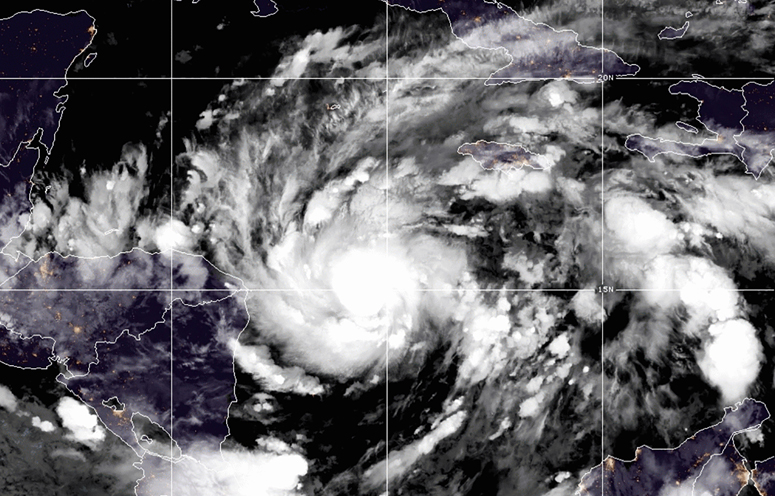
MANAGUA, Nicaragua (AP) — New Hurricane Eta quickly gained force Monday, erupting into a major hurricane as it headed for Central America, threatening massive flooding and landslides across a vulnerable region.
Eta had maximum sustained winds of 120 mph (195 kph) and was located about 85 miles (135 kilometers) east of the Nicaragua-Honduras border, according to the National Hurricane Center. It was moving west at 9 mph (15 kph).
It said the Category 3 hurricane would strengthen further before running ashore by early Tuesday, likely in Nicaragua, where it could bring rains measured in feet rather than inches.
Forecasters said central and northern Nicaragua into much of Honduras could get 15 to 25 inches (380 to 640 millimeters) of rain, with 35 inches (890 millimeters) in isolated areas. Heavy rains also were likely in eastern Guatemala, southern Belize and Jamaica.
Storm surge up to 15 feet (4.5 meters) above normal tides was possible for the coast of Nicaragua. The hurricane center also warned of life-threatening flash flooding and landslides in areas with higher terrain.
Nicaragua’s navy evacuated the Miskito Cays of about 1,650 residents along the coast on Sunday and prohibited launching any boats along the stretch of coastline expected to receive Eta. Offshore residents were taken to shelters in Bilwi, also known as Puerto Cabezas, the primary city of the Northern Caribbean Autonomous Region that is home to some 66,000 people, according to Guillermo González, director of the Nicaragua’s national emergency management agency.
Northeastern Nicaragua is sparsely populated, home to small coastal villages and a large nature reserve.
González said that 88 tons of rice, oil, corn and other food basics had been to the area. The Rio Coco, which makes up part of the border with Honduras, is home to many Indigenous communities. It is known to overwhelm its banks in heavy tropical rains.
Traffic filled the streets of Bilwi on Monday morning as residents scrambled to stock up before Eta’s arrival. Long lines snaked away from cash machines.
“We’re in a race against time,” said Limborth Bucardo, a local, while waiting in line at a hardware store. “We need to reinforce our houses to dampen the impact of the winds a little.” Heavy black plastic, garbage bags, nails and rope were in high demand.
The navy carried families in open boats, mostly women and children with the possessions they could carry from outer islands to Bilwi under a low grey sky.
Nicaragua’s government has also placed northern provinces on alert as Eta is expected to move through the country’s northern mountains after coming ashore.
Eta’s expected path through Central America while dumping prodigious amounts of rain was already raising references to Hurricane Mitch, the 1998 storm that dumped an estimated 35 inches (890 millimeters) of rain during a slow trek across the region.
A National Hurricane Center archive report says more than 9,000 people died in Mitch, one of the deadliest Atlantic storms in history. At one point its winds reached nearly 180 mph (285 kph), though it weakened while meandering off the Honduran coast before making landfall on Oct 29, 1998.
In Honduras, much of the country was placed on red alert for Eta’s eventual passage through the country. It had been raining since Sunday in some areas.
Julissa Mercado, spokeswoman for the national emergency management agency, said firefighters had started evacuating areas most at risk and mandatory evacuations would be ordered soon.
Eta nearly tripled in strength in just 24 hours, rapidly intensifying from a 40 mph (65 kph) storm Sunday morning to a 110 mph (175 kph) hurricane on the threshold of becoming a major hurricane Monday morning. Forecasters warned that could bring life-threatening storm surge, catastrophic winds, flash flooding and landslides when it makes landfall.
Eta is now the eighth Atlantic storm this season to hit the meteorologists’ definition for rapid intensification.
Over the past couple decades, meteorologists have been increasingly worried about storms that just blow up in strength, like Eta. They created an official threshold for this dangerous powering up — a storm gaining 35 mph (56 kph) in wind speed in just 24 hours.
Earlier this year Hannah, Laura, Sally, Teddy, Gamma, Delta and Zeta all rapidly intensified. An eighth storm, Marco, just missed the mark. Laura and Delta tied or set records for rapid intensification. National Oceanic and Atmospheric Administration climate and hurricane scientist Jim Kossin studied the effect and found storms now are more likely to rapidly intensify than they did in the 1980s and “a lot of that has to do with human-caused climate change.”
Eta is the 28th named Atlantic storm this season, tying the 2005 record for named storms. However, this is the first time the Greek letter Eta is being used as a storm name because after the 2005 season ended, meteorologists went back and determined there had been a storm that should have gotten a name but didn’t.
Hurricane season still has a month to go, ending Nov. 30. And in 2005, Zeta formed toward the end of December.
(Copyright (c) 2026 The Associated Press. All Rights Reserved. This material may not be published, broadcast, rewritten, or redistributed.)