We had a few snow squalls pass through earlier this afternoon. Now a bitter blast slides in over the next 12 hours.
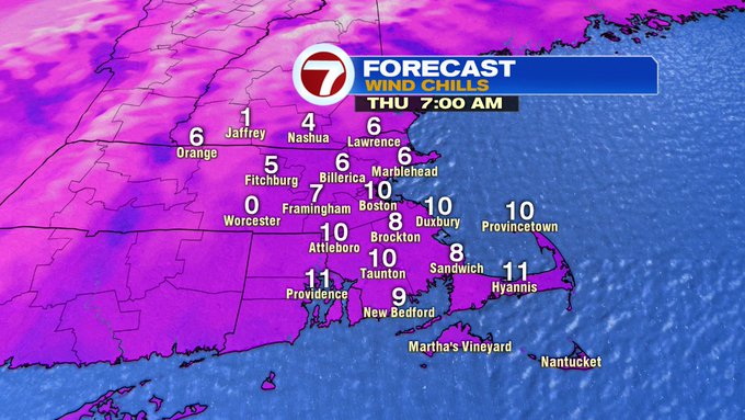
By 7PM this evening, wind chills will be in the upper teens to low 20s and by tomorrow morning, wind chills will be in the single digits!


It will continue to be windy through the overnight, which is why there is a Wind Advisory through 1AM Thursday for most of the Bay State. A few gusts could reach up to 50 mph.

Thursday afternoon, wind chills will rebound back into the teens for most spots.

If you’re not a big fan of the bitter cold, the good news is that the cold only sticks around for one day since we will be tracking a warm-up into the weekend.
Friday, we’re back into the upper 40s and then we see spring-like weather by Saturday and Sunday with highs into the 60s, but of course that brings along some wet weather both days.


With the 60s this weekend, we could be challenging some records for this time of the year. By the next work week, we start off dry and still unseasonably warm, but not nearly as warm as the weekend, with highs Monday and Tuesday into the 40s.
